Imbāba
More than many other parts of the capital, Imbāba has carried throughout its history a considerable legacy of stereotypes and preconceived notions. While its name has shone from time to time in media, books, and speeches, as well as in the political chambers of the government, it has just as often been forgotten and derided. It gained prominence at the end of the nineteenth century, during the construction of the railway bridge which bears the district’s name, then again when its factory workers’ compounds were being built during the 1940s and 1950s. It reached the peak of its fame in the nineties as a battlefield between the government and the political Islamist parties. Living for years under the stigmas of extremism, poverty, violence, and lack of planning, Imbāba today is a society unique in its diversity and rich in its details.
Imbāba in Numbers
Governorate: Giza Governorate.
District: North Giza District
Area: 8.28 square Km.
Population: 695002 inhabitants in one governmental estimate1, one million inhabitants; more in other estimates.
Various government sources quote different figures regarding the population of Imbāba, the largest being close to 700,000, while several researchers claim that the population of Imbāba reaches one million inhabitants, without mentioning their sources (review: Bayat and Denis 2000; Davis 2006.) Its residents think the number is much larger. One youth in Imbāba, having an interest in public affairs, and having monitored elections in recent years, told us that the number of the registered voters in Imbāba is nearly 1.2 million, all of whom are registered to addresses within Imbāba. Additionally, there are a large number of Imbāba residents, especially in the areas of al-Munīra al-Gharbiyya, whose ID cards are still registered to addresses in Upper Egypt and other governates, despite residing in the area for decades.
Imbāba officially comprises2 all areas within the scope of the North Giza Administrative District. This means that in this article we are monitoring a large geographical area, bounded by the Nile to the east, and the ring road to the west, separated from al-`Agūza district to the south by al-Sūdān and al-Maṭār streets, and from al-Warrāq District to the north al-Nasr, ṭarḥ al-Boḥūr and al-Qaomiyya al-`Arabiyya streets. Until recently, this geographical area was included in a single administrative section3 – The Imbāba District – divided into nine zones. These zones were re-divided, and a new district was created, so that currently, Imbāba is divided into two administrative sections that include 18 zones:
- The first division includes 11 zones, which are: Mīt Kardak (Imbāba al-Qadīma), Baḥarī Awal (Ard al-Gam`iyya), Baḥarī Khamis (al-Munīra al-Sharqiyya), al-Masaken al-Sha`biyya (Madīnat al-Taḥrīr), Tāg al-Dowal (Imbāba al-Qadīma), Gizīrat Imbāba, Kafr al-Shawām (Imbāba al-Qadīma), `Abd al Na`eem (`Izbat al- ṣa`ayda), Sīdī Ism`aīl (Gizīrat Imbāba), and Madīnat al-`Omal.
- The second division includes seven zones, which are: Qiblī Thānī (al-Munīra al-Gharbiyya), Qiblī Rabi` (`Izbat al-Maṭār), Baḥarī Thānī (Arḍ al-ḥaddad), Baḥarī Thalith (al-Munīra al-Gharbiyya), Qiblī Thalith (al-Munīra al-Gharbiyya), Masaken al-Maṭār, Mīt `Okba Thānī (al-Baragīl which includes: al-Munīra al-Gharbiyya, Madīnat al-Amal, al-Baragīl, Arḍ al-ḥaddad and `Izbat al-Maṭār.
The Story of Imbāba
We do not have a definitive date for the beginning of Imbāba, but we do know that it originated as a village near the Nile and has been named Imbāba for centuries. It is said that “Imbāba” is a distortion of the original name Nabāba mentioned by the Egyptian Historian Taqī al-Dīn al-Makrīzī (1356 – 1441). He is considered the most important historian in Egypt during the middle ages – the Mamlūk era. His manuscript “Homilies and Consideration by Mentioning Plans and Effects”, known as The Makrīzī Plans, is a description of the planning of Cairo and Egypt, its buildings and its topography. After him came `Abdel Rahman al- Gabartī (1753 – 1825) in his comprehensive description of Egypt “History of Egypt: ‘Ajā’ib al-Athār fi ‘l-Tarājim wa’l-Akhbār.”. Famously known as “The History of al-Gabartī”, it is one of the most important books to chronicle Egyptian towns and villages during that period. In spite of this, Imbāba never recieved an adequate and satisfactory description of its buildings, its residents and their activities like other areas of the capital on the eastern bank of the Nile, as it was no more than a modest village whose name was only mentioned in the history books when it happened to be the site of momentous events.
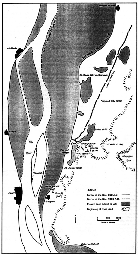
A map of Cairo showing the location of major urban communities in year 1397 A.D (Source: Cairo 1001 Years of the City victorious, Janet L. Abu-Lughod
Religious folk legend: Sheikh Ismaīl “al-Imbābī”
For centuries, the earliest mentions of the name “Imbāba” in history were linked to the popular Sufi myth, “Sīdī Ismaīl al-Imbābī” the righteous man of God. Imbāba was the village chosen by Sheikh Ismaīl to settle in, and he lived there until he died. Subsequently, its name became attached to his last name. His dargah and then his mosque were built in the same spot where he had lived, and are still there now.
It is mentioned in the oral history of Sufism that “Al- `Ārif bi Allāh, Ismaīl Yūsif al-Imbābī” was the son of a Sufi, one of the followers of al-Sayyid al-Badawī – the most famous Sheik in Ṭanṭā. As he grew up he became a protégé of al-Badawī and his successor, `Abd al-Met`āl, studying under them and inheriting their status. He came to Cairo and settled in Bulāq, but the residents rejected him, so he crossed the Nile to the opposite side (McPherson, 1941). Residents often repeat the legend that “he crossed the water on a handkerchief”. He lived in Imbāba until the end of his life. Until this day, the area around the dargah of Ismā`īl al-Imbābī, called Kafr al-Sheikh Ismā`īl, provides the oldest evidence that the settlement of Imbāba, has been in its current location for many centuries.
Some residents of Imbāba and devotees from other areas, to this day, believe in and repeat stories about his miracles. They visit his dargah to seek his blessing and intercession. They also hold an annual celebration for him, and people come from all over Egypt to celebrate his birthday “the birthday of Sīdī al-Imbābī”. It is one of the oldest Egyptian celebrations, as it is just as old as that of Sayyid al-Badawī, which is more than 700 years old. Egyptians at that time had not yet begun relating their dates to lunar months, and therefore, the date of his birthday is the tenth of the month Baounah in the Coptic calendar. This falls on the same day the Ancient Egyptians waited for the Isis teardrop, which fell in the Nile because of her grief over the chopped limbs of her husband. The celebration of that night, known in the inherited popular culture as “night of the drop” continued (McPherson, 1941). These rituals during the night of the drop have cast their shadows on the celebration of al-Imbabī’s birthday. Boats fill the Nile on the night of his birthday as they used to on the night of the Isis “drop” before that. Current residents of Imbāba Island say that they’ve seen crowds coming in their thousands to commemorate the birth of al-Imbābī; sleeping in the streets for nights at a time, in preparation for “the Big Night”. The residents of the island prepared banquets and donated food and blankets to attendees of the celebration.
Despite the residents continuing to seek blessings at the dargah and the continued survival of this legend in the area around it, the celebration on the birthday of Sīdī Ismaīl has (like many similar celebrations) recently declined. This is due to several interrelated reasons, including the decline in Sufism and folk legends, which has impacted the number of enthusiasts coming to the celebration. This is in addition, to the spread of religious ideologies that condemn these celebrations and consider them fads or prohibit them. This became apparent in 1946, when members of the “Muslim Brotherhood” group in Imbāba lodged a complaint to the police against what they described as “violations” during the celebration. Another reason for this decline, according to some political analyses, is the increasing securitization and the government’s desire to exercise control over public spaces in Greater Cairo, and all the cities in Egypt more generally. Celebrations stopped completely in recent years – especially after 2011. Residents attribute this to security considerations, as the Imbābī dargah is located directly behind the police station building.
The military legend: The battle of Imbāba
A great historic battle took place in Imbāba during the French Campaign in Egypt; documented in the writings and paintings as one of the most important battles in the history of the French Army, led by Napoleon Bonaparte. It is signifigant for the fact that Napoleon originated a new military tactic, the infantry square formation, which was considered one of his most important contributions in the military arts. He destroyed most of the Mamlūk army in Egypt at the time, to the extent that they were forced to retreat from Egypt to Syria and rally their ranks. It was considered in French literature as an important victory for Europe, after the French Revolution, over the Ottoman Empire in the Middle East.
This battle took place on July 21st 1788, following the occupation of Alexandria. Napoleon’s army moved to Cairo, where it encountered the Mamlūk forces led by the Georgian Mamlūks “Murad Baig” and “Ibrahim Baig”. He defeated them in two battles; the first a minor battle on the eastern bank, and the second a large, decisive battle in which his army met the Mamlūks’ army near the village of Imbāba on the western bank of the Nile. Various sources quote different numbers for the dead and wounded on the Egyptian side led by the Mamlūks. After the crushing defeat of the Mamlūk army, Mourad Baig fled to Upper Egypt; Napoleon entered Cairo and there laid the foundations for a new local government that did not last for long. Napoleon later named the battle, “The Battle of the Egyptian Pyramids, (al-Ahrām al- Masriyya)”, because the Pyramids could be seen on the horizon from the battlefield; he considered them to be historic witnesses to his victory.
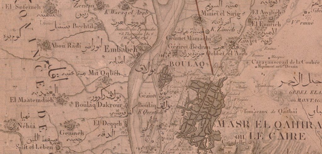
The map of Cairo in 1826 from the Geographical Atlas, one of the parts of the famous work, Description of Egypt, by the scientists of the French Campaign, the village of Imbāba appears next to similar historical villages in Giza, source: Bibliotheca Alexandrina.
The African Darb al-Arba`īn and its Final Station: Imbāba’s Camel Market
“A trip that bestows upon you and another that takes out of your pocket… and a trip that shows you the flaws of a companion compared to your own” one of the songs of the caravans travelling along Darb Al-Arba`īn. The historical legends associated with the name of Imbāba do not stop here. One of the most important legends is the route for trading and religious proselytizing, known as “Darb Al-Arba`īn (the path of forty)”. This is the old road connecting Darfur (in Sudan) to Imbāba. It was formed over hundreds of years and travelled by traders selling camels and goods, back and forth to Egypt and the camel market in Imbāba. The camel market was a big vacant plot of land where camels from Ethiopia and Sudan came to be sold in Imbāba each year. It has been said that the name Imbāba is a distortion of the original name “Nababa”, a name given to it by those coming from the African south which in Amharic (Ethiopian language) means the Egyptian doum palm. Popular accounts tell us that Darb Al-Arba`īn played an important religious role in spreading the Sufi orders and it was said that it was called Darb Al-Arba`īn because it witnessed the birth and dissemination of forty Sufi sects. Others think its name more likely comes from the forty-day trip, which was the duration of the desert trek from central Sudan to Imbāba (although some accounts state that it was to Asyūṭ or Drau in Upper Egypt). The remains of Darb Al-Arba`īn still cut across Egypt’s Western Desert between Asyūṭ and Dakhla oasis, and there are also remains of it in Sudan. However, many people are unaware of its history and the popular mythology associated with it.
The camel market and the neighboring slaughterhouse continued to operate until the early nineties, supplying camel meat to the different areas of Cairo and to the governorates as well. There is a 1989 article in New York Times that describes – according to one of the camel merchants – the 40 day trip from Fasher in Western Sudan to the heart of Cairo; the author states that the market continued to be one of the biggest markets in Africa and the Middle East until very recently.
Contemporary Imbāba beginning to take shape: The building of a bridge across the Nile links the rural center to the capital.
Over the centuries, Imbāba has continued to develop. Until the end of the nineteenth century, Imbāba was not just a small village like the ones surrounding it, but a rural center whose size was close to that of Giza, which had become the heart of urban areas on the west bank. Imbāba encompassed within its scope several adjacent small villages and farms, among them Kafr al Sheikh Ismaīl, Tāg al-Dowal, Kafr al-Shawām, and Mīt Kardak.
Over time, Imbāba acquired a greater importance if compared to villages of the western bank. In 1890, the first steps were taken to turn this village to one of the stations of the Upper Egyptian train line. A railway bridge was constructed coming from the Giza train station, crossing the Nile to reach the Misr station in the heart of Cairo on the eastern bank. Both the bridge and the station were named Imbāba after the village. In 1913 the railway authorities decided to build a new bridge that would accommodate bigger loads and higher traffic density. It was designed to accommodate two railway tracks, two paved roads for cars, and a pedestrian pathway on either side as well. This was a quantum leap, facilitating access to Imbāba from urban Cairo, encouraging the movement of people and goods back and forth, in preparation for its urbanization. A French contractor was tasked with to building the new bridge; he started the construction at a distance of 35 meters north of the old bridge, which continued to function in the meantime.
Construction stopped during World War I (1914-1918) then resumed, finishing in 1925. It replaced the old bridge which was then dismantled and moved. Subsequently, some of its parts were used in the construction of a bridge in the city of Damietta.

A map from the beginning of the twentieth century showing the village of Imbāba which encompasses the villages of Kafr al Sheikh Ismaīl, Tāg al-Dowal, Kafr al-Shawām, and Mīt Kardak, also the police department (station) in the same current location, and Imbāba train station next to the railway extending across the Imbāba bridge. The map of Cairo, Land Registry Department, 1920 source: Egyptian Geographical Society
The Imbāba Bridge was the first and only swing bridge that was electrically operated among a total of 41 bridges crossing the Nile in various areas of Egypt in 1937, according to a Military Report on Egypt for the British Army in the same year. From this report it is also apparent that Imbāba was considered one of the most central and important region of Egypt at the time; it is one of the 11 regions that had road maintenance units, the others were distributed throughout Egypt from its north to its south. A reservoir was built there to pump water to the rest of the west bank of the Nile, in addition to the Giza Waterworks. The main telecommunications trunk line from Upper Egypt passed across its bridge into Cairo.
As we will see from the subsequent development of Imbāba, this bridge played a fundamental role in changing the nature of the area and transforming it from a rural center to a modern city, bearing the dreams and aspirations of the state and its urban planners.
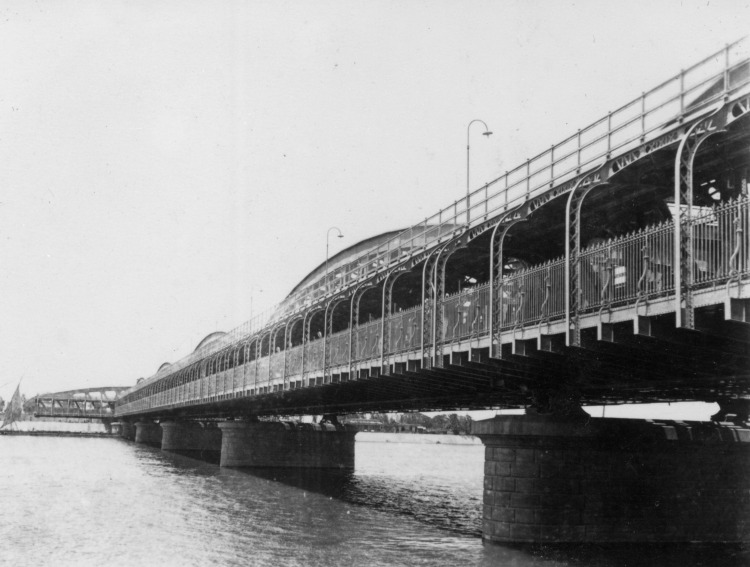
Imbāba Bridge photographed by one of World War II soldiers (1941), published by his daughter in her blog
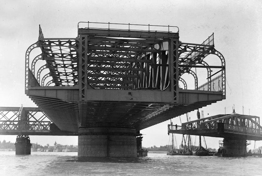
The movable part of Imbāba Bridge when open, (no date)
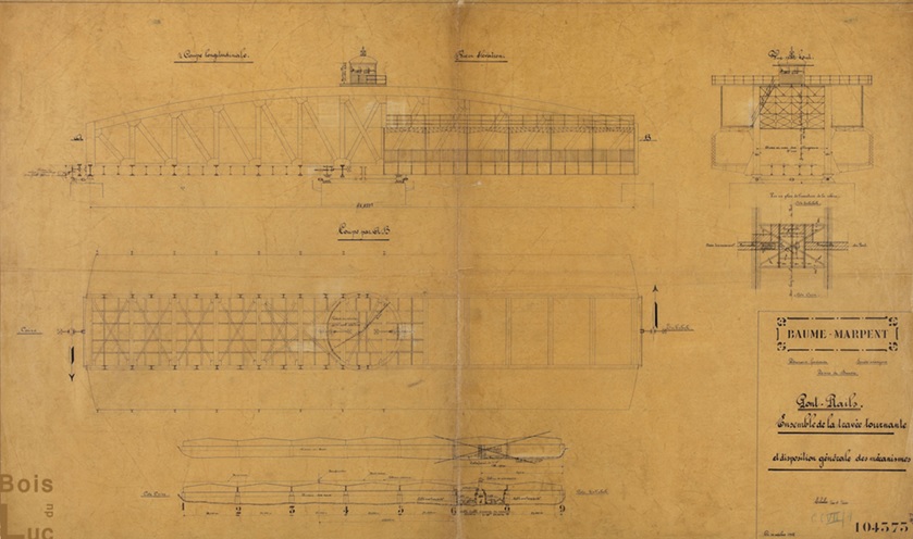
Imbāba Bridge, a diagram of the movable part of the bridge
The riverside of art and recreation for Cairo’s dignitaries, politicians and the wealthy
During this period, the Imbāba corniche, especially the Kit Kāt area, was famous for its house-boats and nightclubs which played an important role in the artistic and indeed the political life in Egypt, especially in the 1930s and 1940s. These nightclubs were an important venue for dignitaries, members of the royal family and British Army soldiers. Within these special places they could spend the evenings, have fun, and carry out deals outside the scope of the propriety and rigorousness which governed their transactions at their places in Cairo. The most famous of these nightclubs and the one mentioned most in the history of that period was the Kit Kāt nightclub, which had survived for many years. It is said that it was built at the time of the French Campaign at the heart of the area currently called the Kit Kāt Square. This famous club witnessed the rise of many famous actors, singers and belly dancers such as Badī`a Maṣabnī, the most famous actress of her time. After her came Tahiyya Karioka, Na`īma `Akef and others. It was also a witness to sensational stories of espionage and major political conspiracies. The most famous of these is the story of the belly dancer Hikmat Fahmī, who had danced in front of Hitler in Germany. Her relationship with the British soldiers in the Kit Kāt nightclub had made her eligible to be commissioned to spy on the Allied forces in favor of Nazi Germany. The tradition of artists owning house-boats on the Kit Kāt Corniche continued for several decades, having been the scene of a boisterous social life filled with parties, meetings with friends as well as the birth of many of the artistic innovations that we have today.
Industrial building in the rural suburbs on the outskirts of the capital
The phase of industrial building in Imbāba began at the same time – the beginning of the twentieth century –with the flourishing and booming of industries in the 1930s. This is contrary to the popular assumption that industrial building in Imbāba was linked to the reign of Gamāl `Abd al-Nāṣir. Just by looking at a map of Cairo in 1930, we can see there were already a number of factories and an even larger number of brickyards occuping Imbāba. By investigating and researching the list of factories that were built in the late 1930s and 1940s, we find that many of these important industrial factories had specifically been built in Imbāba, as it was an emerging industrial zone on the outskirts of the capital. At that time, industry was a hot issue on the national policy agenda; legislation was drafted for it, and National Assembly sessions and meetings of political parties, major capitalists, and property owners were devoted to discussing it (Beinin and Lockman, 1998.) The interest in building large, modern factories in that period was not limited solely to politicians, who promoted industry as a pillar for national independence, or to capitalists who merely wanted to invest in a new promising field. It had also become an area of competition between the most prominent architects and structural engineers at the time, who were specialized in design and construction. Industrial buildings allow more room for the adoption of modernist architectural styles. With their abstract styling, simple lines and state of the art methods of construction, these types of designs had prevailed in Europe (where most these professionals had received their education and training) and had become part of the architectural identity of that era. (Bodenstein, 2010)
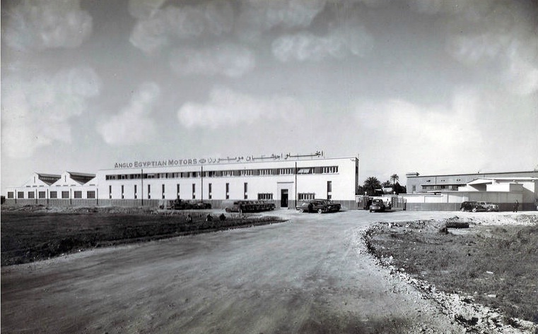
The building of Anglo – Egyptian Motors in Imbāba, designed by architect Maḥmūd Riād, 1937
Imbāba, like other industrial areas, acquired a number of these important buildings. For example, the Anglo–Egyptian Motors Company, designed in 1937 by the architect Maḥmūd Riād. He was the same architect who had designed the NDP building on the opposite Corniche. The building was later burnt down, and is being demolished at the time of writing this article. Also among them is the Chourbagui Textile Factory – the “King of fabrics” according to the expression used by the press of that era – which was designed by architect `Alī Labīb Gabr in 1940. This building was of such significance that the prominent specialist publication “al-`Emara (architecture)”, 4 devoted an entire issue to review the design of the plant and its facilities as an example of “the ideal modern factory”. The article explained the advantages of the modern production lines, the large halls and the methods of construction used (Reynolds, 2012). In the following years, the Chourbagui factory in Imbāba continued to be one of the largest and most important factories of the period. It was famous for the important role played by its workers in the Egyptian labor movement and the major sit-in that Imbāba witnessed in the 1950s5. The Chourbagui factory remains in operation to this day and is one of the few remaining factories in Imbāba following the sale of most of the other factories, their demolition and the use of their land for other purposes.
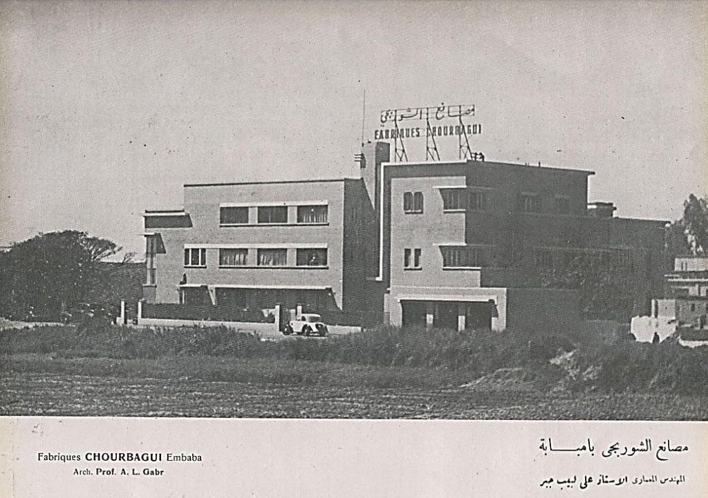
Chourbagui Factory, Imbāba branch, designed by the architect Alī Labīb Gabr, Pioneer Egyptian Architects, Shaymaa `Ashūr 2012
During subsequent decades, Imbāba experienced wholesale relocation of government owned industrial establishments from Būlāq to the opposite bank. The most important step in this relocation was the construction of the new government Printing Press on an area of 35,000 m2. Architect Alī Labīb Gabr was commissioned to design it in 1956, and it was officially moved from Būlāq Abū al-`Ela in 1973. Furthermore, the Maritime Shipyard, founded by Moḥamed Alī Pasha in 1812 on the Būlāq river bank for building warships, continued in operation for centuries until it was moved to Imbāba in 1967.
In addition to these major projects, which are landmarks in the history of Egyptian industry and architecture, Imbāba had a large number of small and medium-sized industrial establishments. For this reason, it was cited in several studies about that period as one of the emerging industrial areas. In the 1960s, new factories in Imbāba and other industrial areas continued to be built in large numbers, especially considering the production of electricity by the High Dam and the increased extraction of natural energy resources like oil and gas from the Red Sea, the Delta and the Mediterranean Sea. These provided the power for the government’s ambitious national project for an industrial renaissance (Bodenstein, 2010). Until the present day, some of these industrial factories or their empty plots, once they had ceased to operate and were demolished, continue as famous landmarks in Imbāba. Prominent examples are The Chairs factory, the Sugar factory, the Chourbagui Factory, the shipyard, the Printing Press, the Grain Silos and others.
The laborers’ housing in Imbāba, an urban seed in the heart of the countryside
In the context of booming industrial projects in Imbāba in the 40s, 50s and beyond, it is logical to expect the emergence of major housing projects to accommodate the workers arriving in the area. But as we follow the story of “the Laborers’ Town” from the beginning, we discover that the birth of the idea dates back to the 1920s. The purpose was not to house the community of Imbāba’s laborers, which had not yet materialized, but it was a part of a larger project to reshape the Būlāq district, the most crowded district in Cairo at the time – according to an official statistical study – (Volait, 2001), and to move a section of the population that, together with its poor district, troubled officials and those interested in urban planning. The reason for this plan was that Būlāq did not match their criteria for a historical Cairo, such as the areas of Fatimid Cairo, and was not up to being part of the prestigious, twentieth century Cairo with its (Khedive/Ismail) European planning such as the Downtown and Heliopolis.
This all started when the Egyptian planner Engineer Sabrī Maḥbūb, who had been educated and trained as a city planner in Britain, took over the Organization Bureau in the Egyptian government. He designed, for the first time, the master plan for the modern city of Cairo, which had involved, among other planning visions and proposals, the re-planning of the Būlāq district. He described the district in his study “Notes About Cairo”, as “the vilest of slums” and described its inhabitants as “the most degenerate class of inhabitants, hordes of beggars and vagrants, intermingling with a large number of workers, artisans and so forth” (as mentioned in Volait, 2001). This was how Maḥbūb saw the demographics of the first urban community he proposed to establish in Imbāba. It is quite likely that Imbāba itself and the indigenous inhabitants of the village did not receive Maḥbūb’s attention as it was nothing but a rural area on the outskirts of Cairo. The plan for the new Būlāq district was to demolish and rebuild all the streets and buildings, and to transfer the government industries such as the railway workshops, government printing press and others, along with the residents working in them, to a new town that would be established especially for them in Imbāba. This would afford the planners an opportunity to dislodge the existing physical structures of Būlāq, with its narrow streets and high population density and replace it with elegant ones with wider streets and larger public spaces (Volait, 2001). This reflects to a large extent, the situation today where the demolition of slums, and the relocation of residents to new towns at the outskirts of the city continues to be the modus operandi.
The plan also included the proposed urbanization of the west bank facing the capital, i.e. Giza and Imbāba, and all that lies in between them to build a new city that was dubbed by the media of the 1930s “al-Madina al-Fu’adiyya” after King Fu’ad, however, it was never built. The plan additionally included the construction of social housing projects, especially for laborers and various junior public servants, many of which were implemented. According to a detailed study that Maḥbūb later annexed to the plan, he proposed building a modern, planned town that would accommodate 5,000 laborers and their families, with funding from the state, and moving the residents and industries of Būlāq to this area. He chose its location in Imbāba on the opposite bank west of the Nile, which was linked to the northern part of Cairo through the Imbāba Bridge that facilitated the movement for pedestrians, vehicles and trains. Maḥbūb’s plan was never implemented at the time for a variety of reasons (for more details see Volait, 2001).
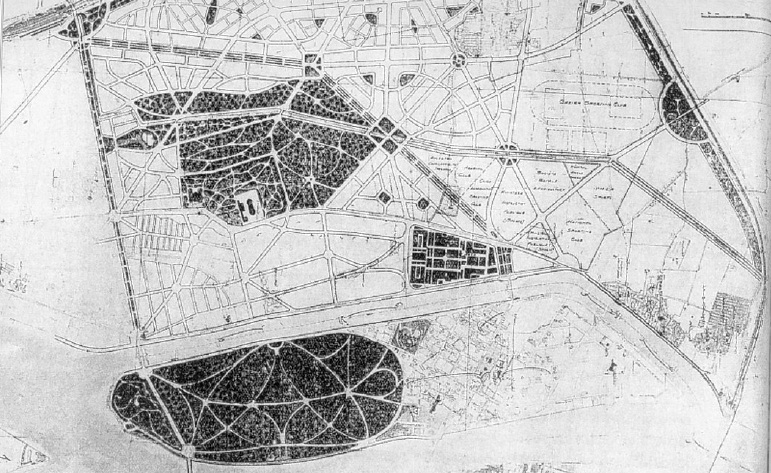
The initial visualization for the western bank town in the twenties of the twentieth century, Maḥbūb (Maḥmūd Sabrī Maḥbūb1934 – 1935) Source: Volait 2001
After nearly two decades and after Maḥbūb’s was no longer part of the project, the laborer’s town was finally constructed in conjunction with increasing laborers’ housing projects – both governmental and private. It was constructed next to Imbāba’s historic villages on its agricultural land, at the same spot, north of Imbāba Bridge and of almost the same size that Maḥbūb had suggested. Būlāq remained largely as it was, only later relocating some residents, the printing press and the shipyard workers to the new town. Engineer `Alī Melīgī Mass`ūd was assigned to plan the city in 1946 in his capacity as the director of the City Planning Bureau in the Municipalities and Local Councils Office. He was a member of the British Royal Institute for Town Planning – which showed that the European, and especially British, vision in urban planning was preferred by the Egyptian government at the time. The implementation of the plan for the “laborers’ housing” project started on an area of 1.4 km2 of agricultural land. The government also commissioned specialists – Maḥmūd Riad and Aḥmed Ḥussein to write the report “The Housing of Citizens with Low Income”, which was published in 1949 – to determine the value of rents suitable for the Egyptian working class (Volait, 2005). All this was in conjunction with the formulation and approval of the first law for State Subsidized Housing in Egypt, “Law No. 206 year 1951 concerning Public Housing” 6 (Sims, 2012) This sheds light on the importance of the social housing issue, specifically the model of the laborers’ town in Imbāba at that time, and how it took the lead in the political agenda in a number of ways.
Mass`ūd designed the new town with a network of wide, uniform streets, interspersed with green areas. He allocated river buses and a tramway line to serve the town, and devoted the town center for services and important establishments such as a hospital, schools, marketplace, cinema, a children’s park and parks in general. Mass`ūd was also keen to devote some of the passages for pedestrians only. 75% of the housing was designed to accommodate one family with a unit having two floors and a back garden. The remaining 25% were also two floors, however, each floor was divided into two apartments. The buildings were close to each other (terraced) and had a balcony and a back garden (townhouse), and their façades varied between stone, brick, and lime. It is clear that Mass`ūd’s designs were influenced by the British model of traditional working class housing of an earlier period (Volait, 2005).
The first phase was completed in 1950, and it included 1106 housing units out of a total of 6000 units that had been planned. The units were delivered, and the laborers got their houses with permanent contracts. The value of the rent was determined by the cost of construction, a unit’s spatial dimensions, and its location. It is worth mentioning that some of the current residents of the laborers’ town have the documents with which their parents received their homes in 1951. Later, those units became the family homes and more than one floor was built without authorization to accommodate a growing family and the needs of the children and their new families.
Imbāba is a town now, an industrial town that attracts residents and is capable of expanding
The building work of the “laborer’s housing” came to a standstill in 1952. In fact, the project of the 6000 units that Mass`ūd had designed, and Maḥbūb had developed was never completed – at least theoretically. The project ended after its first phase was completed. There is nothing in the available literature that indicates a direct relationship between the abandonment of this promising project and the critical political situation during that period. However, after the exceptional political developments during the subsequent two years, in 1954 the state began to build a new town for the same purpose – housing laborers and junior public officials – at the site which had been assigned for the project’s second phase, but with a new plan and under under the new name “Madinat al-Taḥrir”. The construction continued in Madinat al-Taḥrir in the following years. Its plan was even replicated in two similar projects in Ḥilwān and Ḥilmiyyet al-Zaytūn. More than 4,000 housing units were built in the three areas in the period between 1954 and 1958. These were the last major subsidized social housing projects, designed in accordance with the concept of a private residence for individuals or families. Those houses resembled middle class villas, which had a private entrance, a back garden and the potential of vertical expansion for the family in the future. After 1960 the subsidized housing policy changed completely; multi-story apartment buildings are designed to accommodate multiple families became the conventional model of laborers’ housing and continues to be to this day (Volait, 2001).
Some turn a blind eye to the possibility of a connection between the political decision to abandon the original plan and build a new town to be called “al-Taḥrir (liberation)” after the Free Officers deposed King Fārūk and declared the Republic, and the customary desire of Egyptian political systems to inaugurate major projects to be attributed fully to them rather than being associated with the efforts of a former regime, to serve as a testament to the stability of their reign and their dedication to development efforts.
Several major projects followed the Laborers and al-Taḥrir towns within Imbāba, among them Madinat al-Sādāt, and Arḍ al-Game`iyya Housing. Some of those were governmental projects and others were private, but all had been planned, were official, and were created in accordance with the government’s visions for housing and development, or at least with its consent.
The village, the Town and what Lies in between: Unauthorized Extensions of Construction
The official extensions of the town, planned and built by the government, were not the only urban development activities in Imbāba as there were various other forms of unauthorized urban extensions in the area. One of the informal extensions was associated with the official laborers’ towns. Two researchers from the Institute for Urban Transformation Studies (ETH Studio Basel) noticed, in an aerial photograph of Imbāba from the 1950s, haphazardly planned houses adjacent to the houses of the Laborers’ town. The researchers believe that those were originally built as temporary housing for construction workers in the Laborers’ town and then Al-Taḥrir town during the late 1940s and 1950s. They then settled there permanently. The researchers state that this was the first unauthorized urban construction in Imbāba (Peronnet and Rodemeier, 2010).
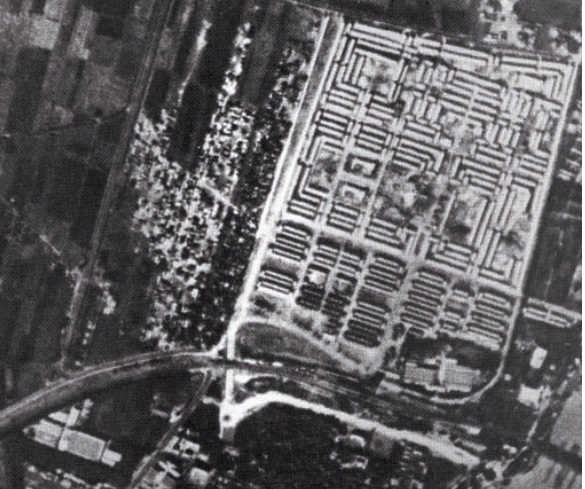
An aerial photograph from the 1950s showing unauthorized houses which were said to be those of the workers in the project of “Laborers’ Housing”
The completely unplanned villages– which reflect the nature of construction in the Egyptian countryside– continued to grow and expand, following the same inherited and unauthorized patterns. In spite of the construction and expansion of the planned town, the villages remained clustered to the north of the railway line and the Imbāba Bridge. This formidable wall continued to separate the historic villages of Imbāba from its modern laborers’ towns. Government plans did not involve the demolition of old villages or the relocation of their residents to the new urban areas with their modern residential blocks, gardens and wide streets. It is obvious the plans did not take into account the needs of those people, nor the far-reaching impacts those new developments will have.
The extraction of topsoil from agricultural land, which was the source of income for its residents, continued unabated. Due to governmental inaction, the old rural houses south of the bridge remained in their state, towns continued to be constructed one after another adjacent to these villages with their traditional, narrow winding streets and irregular buildings. With population growth, changes in the economic activities of the village residents, and general socio-cultural changes, successive generations of the residents demolished their old rural houses. Those consisted of a ground floor with an internal courtyard surrounded by rooms where the children and their families lived. After demolishing their old homes, they divided the land of the family house into several plots and each built a separate house for themselves and their family, then for the families of their children and grandchildren later on. The current residents of old Imbāba describe this change simply: “each one can close one’s own door”, referring to the newly created need for privacy among the members of a family, which had been developping in the Egyptian rural communities more generally. With time those houses reached the height of three or four floors, overlooking the same narrow streets, the flats now lacking in sunlight and ventilation.
As a consequence of the increasesing price of land next to or within the urbanized areas and the changing nature of the economic activities, residents increasingly sought to sell agricultural land, parcel and build on it on an unauthorized basis. The continued government activities in extracting topsoil from agricultural land, and the expansion in the urbanization of Giza – which now includes large, upscale areas such as al Awqāf town (currently al-Mohandisīn) – adjacent to Imbāba has exacerbated this trend driving further unregulated urbanization. The current urban fabric reflects the agricultural divisions that once were. For example, the old canals were filled in to become the main streets between the houses. As the inhabitants did not build those new neighborhoods according to a designed urban plan, the provision of appropriate service areas, green spaces, or suitably wide public spaces that could serve as transportation hubs and for other purposes, were not taken into consideration.
Imbāba was not the only area undergoing this kind of development. The type of unauthorized construction and urbanization had become the most accommodating for population growth in the Greater Cairo Region, where the proportion of residents in informal areas rose from about 15% of the population in 1960 to 64% in 2009, (Sims, 2012). Government planning efforts were not sufficient, effective or responsive enough to accommodate the population growth or stem the tide of informal settlement.
What was once agricultural land on the outskirts of Imbāba has now become the center of Imbāba and entire residential areas have now grown on those plots. The residents of those informal areas within Imbāba are diverse. While some quarters were formed of migrants from various governorates or Cairenes looking for a house with suitable rent, other areas were more distinctive in their formation. Some are entirely made up of families or tribes from Upper Egypt who came to Imbāba in a mass exodus that lasted for years. They formed their own societies, which imposed its characteristics over the place, so the new settlements were named after them and were formed according to their norms. Some of them still exist today such as `Izbat al-Ṣa`āyda, near Kīt Kāt square. It was settled in the 1940s and 1950s by migrants from Upper Egypt, who belonged to large and famous families, such as al-Nowayta and al-Fagar from Qinā Governorate. Ostensibly, the first family member who went to Cairo settled and worked in Zamālik, later buying vast areas of agricultural land in Imbāba and bringing relatives to cultivate the land and live there. He became their mayor, and more of his relatives came to Imbāba, and built temporary modest houses – huts made from palm leaves. Over time, they settled down and developed their residential colony with the help of a building contractor who divided the land into streets and constucted buildings that had apartments and shops. It was called `Izbat al-Ṣa`āyda (Upper Egyptians estate), and the area still carries the same names amongst its residents.
Other areas of Imbāba were formed entirely by migrant communities similar to `Izbat al-Ṣa`āyda. Some of them settled permenently, while others came and left, no longer existent in Imbāba except in memory. One particular example was the “rubbish collectors” from Aṣyūṭ, who occupied an area of land in Imbāba for about 40 years, during the period between 1930 and 1970. They lived in al-Baṣrawī area in al-Munīra al-Gharbiyya, and collected rubbish from all of Greater Cairo. They sorted it, raised pigs and sheep around their informally built houses, and set up a community according to the functional needs and the financial abilities of its members. The contemporary residents of Imbāba remember them with some disdain, seeing their community as nothing but people who raised “impure” pigs, the area around them reeking with the smell of rubbish. The colony of rubbish collectors continued to be a part of Imbāba until they were confronted with an eviction ultimatum issued by the Governor of Cairo in the late 1960s, after which they were moved to the bottom of al-Muqaṭṭam, a hill allocated to them through a presidential decree from Gamāl `Abdel Nāṣṣer, “Munsha`at Nāṣṣer” as old rubbish collectors recount.
Thye construction of the ring road around Imbāba at the end of the 1980s, encouraged the encroachment upon the agricultural lands remaining in Imbāba, as it did in other areas. Today, almost no agricultural lands remain within the scope of Imbāba. The unauthorized construction of high-rise residential towers around the ring road extended to the Bashtīl area on the other side of the road, which, until recently, was a village affiliated to the rural Imbāba municipality – which no longer exists administratively. What happened was an expected – or rather planned – result of the construction of the ring road. With an attractive location on the sides of the most important highway around Greater Cairo the value of the land increased, making the revenue from building on it and investing in its real estate, especially in the light of a continuing housing problem, much more profitable than cultivating it. In addition, the problems faced by the farmers in Imbāba made cultivation seem more like a struggle than an economic activity to earn a living. Again, Imbāba was not unique in this development, as the rate of urbanization on the outskirts of Greater Cairo increased almost three fold after the construction of the ring road (Piffero, 2009). The “Long Term Development Master Plan” prepared by “Ile de France” Institute and approved by Hosni Mubarak in 1983 – proposed the construction of the Ring Road as a belt around Cairo and considered it “the most urgent of measures” to limit the urban sprawl (Dorman, 2007). However, the ring road achieved the opposite, despite the provisions made in the plan as to not to “encourage urban growth on the agricultural areas,” and support the construction of other informal areas along the length of the road, especially arable land on the outskirts of Giza (Raymond, 2000) . This proves the lacking vision of the plan which did not take into account the economic and social conditions, and the total lack of local justice across the country that led to the creation of those settlements. There is no need to highlight the failure of these planning provisions in achieving their goals as they have clearly only succeeded in achieving the exact opposite result, just as we have seen in the mini model of Imbāba.
Islamic Emirate in Imbāba
Political Islamist groups have a long history in modern Imbāba, starting with the Muslim Brotherhood, the Salafis, al-Tablīgh wa al-Da`wa and ending with al-Gama`a al-Islāmiah. The most violent group, al-Gama`a al-Islāmiah had the greatest influence in urban Imbāba, making its name synonomous with controversy and conflict. Here we will describe what we have come to learn about it.
Al-Gama`a al-Islāmiah decided to colonize the heart of the capital and grow there, in al-Munīra al-Gharbiyya, west of Imbāba and Greater Cairo, and fight the state for control over the area. According to Patrick Haenni, the struggle over the public life in al-Munīra al-Gharbiyya was between the union of “al-Okhwa fi Allah (brothers in God),” – which the Islamic groups founded, and mobilized the society around – and the union of blood in the form of “tribes and families” and lastly unions formed around geographical origins which consisted of “people from the same governorate” (Haenni, 2009). He demonstrates how community leaders in that period were replaced to reflect the new balance of power. He also reflects on the role of the state and its authority in that conflict – which was sometimes overt and more often covert. In addition to questioning how this conflict related to the state and the citizen, and how these conflicting relationships changed the structure of daily life in Imbāba.
The influence of the Islamic groups was very apparent in the way streets and mosques were named. “Al-Īmān Bellah (Belief in God)”, “al-Ikhlās (Loyalty)”, “El Da`wa (The Advocacy)”, and “al-I`timād (Reliance)” were not conventional names for mosques in Upper Egypt or anywhere else. Traditionally, the mosques were named after the persons who had built them, one of the Holy men of God, historical Islamic symbols or community leaders.Similarily, streets were given names such as “al-I`timād Street”, “al-Gihad Street (Holy War)”, and “al-Saḥwa Street (Awakening)”. The goal was not just the Islamization of urban space, but also to distinguish them from those built by the dominant Upper Egyptian families (Haenni, 2009). The political Islamic groups gained popularity and support, which many link to the services they offered to citizens who were abandoned by the state and then found themselves in desperate need of basic services. For example, Anṣār al-Sunna al- Muhammadiya built a mosque and two schools in Imbāba. Additionally, they provided medical care and implemented social programs in an area of al-Munīra al-Gharbiyya. This helped to increase their popularity and the residents’ confidence in them (Bayat, 2009).
The relationship between apolitical residents and the Islamic groups was not always harmonious as charity work, economic aid, reconstruction and religious advocacy were not the only aspects of the incursion of Islamic power into the region. With the expansion of their authority several manifestations of violence emerged in order to exert control over the public domain in Imbāba. The groups even recruited well-built young people who have a history of bullying and criminality to deploy in street wars. Weddings became a key target for Islamist violence in Imbāba. It was a common sight to see members with chains and blade weapons attacking street wedding celebrations in which alcohol, hashish and belly dancers were traditional. The inhabitants of Imbāba started to become suspicious of the nature of those groups, who had previously been appreciated because of their religious commitment (Haenni, 2009).
Some of the contemporary residents of Imbāba who bore witness to that time told us that Islamist leaders had so much power and control over some areas that when they planned to hold wedding celebrations – the biggest and most important social event in public life– they needed to go to the police station to get the “permit” – an unauthorized verbal permit – where they would be told that they first had to get Sheikh Gaber’s permission7.
When the 1992 earthquake hit Cairo (the most destructive in the history of modern Cairo) the government’s response was inadequate and their sheer incompetence in rescuing victims became evident. On the other side, the zakat committees in mosques and Islamic groups provided tents, blankets, food and other urgent needs to the affected residents. Naturally, their immediate response to the disaster improved their image among the public and increased their popularity, leading some to claim that this moment of popularity encouraged the Islamists to stand up against the state more directly and clearly (Singerman, 2009).
The proximity of Imbāba to the center of the capital definitely had a chilling effect on the central authorities. Its authority was not being challenged in a remote part in Upper Egypt, but at the heart of a city where it should have full control. According to the security reports, the Ministry of Interior aimed to liquidate what it called the triangle of violence, which is comprised of Asyūṭ, `Ayn Shams, and Imbāba. There are numerous reports about the critical moment that changed the direction of state policy toward the Islamist groups in Imbāba specifically, from ignoring and sometimes even cooperating with them, to what became a fierce confrontation. The media reported that the Islamist group had announced the independence of the region under the name of “The Islamic Emirate of Imbāba”. Researchers claim that international news agencies, particularly Reuters and the Associated Press are the ones who coined this expression. Other reports claimed the spark was a demonstration against the death penalty received by some Islamists during a military trial in Alexandria. It was also alluded that it was the result of the Islamist group showing the banned video of the assassination of Sadat on televisions they had put up in the streets (Singerman, 2009). One or all of these reasons served to enflame a war between the state and political islamist groups in al-Munīra al-Gharbiyya, with its most important manifestation being the siege of Imbāba by security forces in December 1992. This episode has continued to influence the public debate for a long period of time, so much so that it inspired the film makers of “The Blood of a Deer” to produce a film 12 years after the events, inspired by one of the stories of the siege.
The siege of Imbāba as a turning point in urban policies
“Between the 8th and 9th of December 1992, an unknown nieghborhood was transformed into a symbol. Imbāba was besieged by 16,000 security personnel led by 2,000 officers, in one of the biggest security sweeps in the history of Cairo. It brought this informal community into the limelight, where it could no longer be ignored. This community now had a name, and soon it would be the subject of an abundance of descriptions, formal debates, and specialized analyses for determining its geographical borders as described by Eric Dennis (1994) in Singerman ( 2009).
The area was blockaded by bulldozers, police dogs, security vehicles and other equipment – some described them as worthy of a war between two regular armies. Hundreds of area residents were arrested, and a few were killed during a siege that lasted six weeks (Singerman, 2009).
This incident was a significant landmark in the history of state dealings with informal urbanization. The government’s actions aimed at tightening the security over areas considered shelters of their principal political opponents in the 1990s, the followers of the Islamist trend and, the accompanying media discourse established attitudes that molded public awareness and perceptions of these areas. This happened abruptly, even for the residents themselves. This discourse has shaped the national policies and plans regarding informal areas for the past two decades. No longer are they considered peasant areas which threaten the urbanization of the city, they are now areas of violence, extremism and lack of ethics. Up to this day, a discriminatory and provocative discourse exists against the residents of informal areas, which are, for the most part, mainly inhabited by poor people.
On the 1st of May 1993, a few months after the siege, President Husnī Mubārak tasked the government with the immediate implementation of a developmental program for informal areas in all governorates to provide them with important services and facilities. The United States Agency for Development (USAID) had already started to pave streets and develop the drainage system in Imbāba. European NGOs followed suit, implementing various community development projects. In turn, the government announced a five-year national plan to implement development projects in informal areas, from 1993 to 1998 at a cost of 3.8 billion Egyptian pounds. Al-Ahram Weekly reported that until 1996, 127 out of the 527 targeted areas had been fully developed. As expected, al-Munīra al-Gharbiyya in Imbāba received greater funding than any other area in the Greater Cairo Area (where the majority of targeted areas were). Between fiscal years 1992-93 and 1995-96 more than 372 million Egyptian pounds were allocated for the development of al-Munīra al-Gharbiyya alone (Bayat, 2009).
Imbāba had become fertile ground for research and analysis. Research was conducted, and many studies and articles were written about the informal areas, analyzing what had happened in Imbāba and the so-called “phenomenon of informal areas”. This is despite the fact that this pattern of urbanization had existed for decades before. For many segments of society such as people with average income, young people, newly married couples, poor people and immigrants from both urban and rural areas, informal housing is the only option. Imbāba captured the attention of the media, Egyptians intellectuals, specialists in Middle Eastern Studies in Europe and America, international organizations and major financial bodies. Imbāba became al-Munīra al-Gharbiyya, and al-Munīra al-Gharbiyya was Imbāba; the informal Imbāba, the land of poverty, political violence, crime, extremism, ignorance and turmoil. All other facets of Imbāba disappeared from sight for years.
Imbāba experiences open public domain after 2011
We notice that as soon as Imbāba, similar to other districts, experienced relative freedom after January 2011, the diversity of Imbāba’s residents, the differences in their living conditions and their political leanings became apparent and surpassed any generalization, that had been made thus far. Despite the flood of news and events throughout the country, especially in Greater Cairo which took center stage during and after January 2011, Imbāba attracted the spotlight more than once during the past few years. For one, it was renowned as an important starting point for the massive political demonstrations in 2011. The crowds would start out in the streets of Imbāba and meet at several different points, the last and most important of which is Khālid ibn al-Walīd mosque in Kīt Kāt Square, then head to al-Taḥrir Square downtown. Several organizations emerged to defend the rights of Imbāba residents; such as the Imbāba Popular Committee for Defending the Revolution. Electoral conflicts abounded there (as in other places) between different camps. Ironically, Imbāba, which had been branded as an Islamist stonghold, voted dramatically against representatives of political Islam in the 2012 presidential elections. It was said that Islamists left it to go to other areas after having been targeted in it throughout the 1990s. In reality, we do not have much information about the political affiliations of the residents as we cannot list all the organizations and social movements, neither today nor ever, because monitoring such affiliations requires the presence of effective citizen participatory mechanisms that would enable the monitoring of citizens’ attitudes, preferences, and demographic data. All of those directly affect the form of urbanization that takes place, and people’s lives within it.
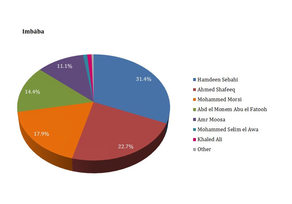
The results of the first round of the presidential elections 2012 Imbāba election committee.
Source: official website for presidential elections 2012
The past few years have revealed much of the tension bubbling under the surface in Imbāba, manifesting itself in instances of sectarian violence. The most famous and cruelest incidents occurred on the two main streets in Imbāba in May 2011, resulting in 15 deaths, and 242 wounded, according to a report of a human rights organization. Following that, two churches were burnt in Imbāba, namely The Church of Saint Mina and The Church of the Virgin Mary. As a result 190 people were arrested and referred to the supreme military prosecutor’s office for interrogation. The situation necessitated the intervention of the army for the protection of the buildings, as well as the supervision and financing of their repair works carried out by a team of specialized monuments restorers. While those events took on the character of a conflict between religious denominations, the authorities failed to fulfill their duties in containing them and minimizing their losses. Similar to other neighborhoods Imbāba saw violence and conflict between the State and its Islamist opponents after the 30th of June 2013. The incident that had the greatest impact on the shape of surrounding urban area was a bomb explosion in front of the Courts Complex building on the corner of Ter`et al Sawaḥel Street on the 14th of January 2014, which did not result in loss of life, but coincided with the referendum on the new draft of the constitution. The building is still being repaired until today.
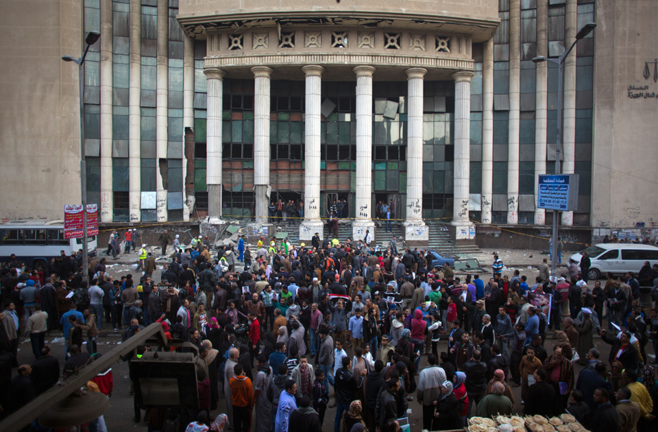
An explosion in front of North Giza Court Complex on Sūdan Street, 2014
Source: Al Ahram newspaper
However, in a larger sense we should not focus on the events of political violence, where factors often overlap to create a justification for evacuating the public domain and taking control of it. The significance of those events should not be disproportionately inflated when hundreds of thousands of people go on about their daily lives, spontaneously using public spaces to buy, sell, meet in cafes, and attend weddings, funerals, festivals and other activities in a dynamic area, which is full of both private and informal shops that provide for daily needs, covering almost everything one can imagine in terms of goods and maintenance services.
The place and its people
Imbāba today is one of the most densely populated areas, not only in Cairo but in the world. It lies to the north of the capital on Giza governorate’s Nile bank, where the corniche is considered its main façade. For those coming from the south, along al-`Agūza corniche, it can be recognized on arrival by the famous Kīt Kāt Square. Bridges play an important role in connecting Imbāba to the various districts in Cairo governorate; the Imbāba Bridge and al- Saḥel Bridge lead to Būlāq Abū al-`Ela, and from there on to the town center, Old Cairo, and the Ma`ādī Corniche to the south, and Rowḍ al-Farag, al-Saḥel, and Shubrā to the north. Imbāba shares Sūdan Street – one of its main streets – with El Mohandisīn district, and it also shares al-Qawmiyya al-`Arabiyya Street – one of the most important main streets in Imbāba – with al-Warrāq to the north. The ring road connects it to several areas around Greater Cairo by means of microbus routes and stairways that were constructed by the residents themselves.
Imbāba residents are crowded in its buildings which were formed by mixing all the economic and physical strata of the urban and rural areas, planned and unplanned. We find middle-class areas, next to governmental public housing and beside informal slum buildings, just a few residential blocks away from a tower block whose ten or more floors overlook a broad street, and hide less expensive residential buildings lining the narrow streets behind it. In addition to the diversity in its building configuartion, Imbāba is also characterized by the demographic diversity of its inhabitants’ in terms of their origins, their varied social and educational backgrounds, and the economic sectors in which they work. They differ even in their perception of the district they call home, its landmarks which some would consider important while others view indifferently and its problems as those differ from an area to the next. We have identified the differences in perceptions of the residents of the factory workers’ compounds and employees and those living in al-Munīra al-Gharbiyya for example, and how specific stereotypes of “the other” shaped this perception. That is to say, the perceptions of Imbāba’s residents themselves of their district is not homogenous; Imbāba is a large district, everyone often moves within one’s neighbourhood, with no need to visit other areas within Imbāba. Thus, to understand the urbanisation of Imbāba, we will devide it into areas, and try to take a closer look at the nature, diversity and distinctive features of each area8.
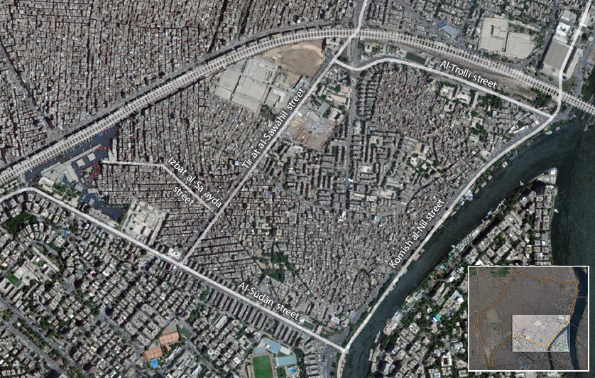
The historical villages of Imbāba merge with the housing of Upper Egyptians and the governmental housing in the area bordering al-Mohandisīn and facing the Zamalek Island, separated from it by a branch of the Nile with its famous house-boats.
The area south of Imbāba, confined between the Nile corniche, Sūdān Street and the railway line, is one of the areas that have the clearest geographic boundaries and is home to many of the diversities and contradictions of Imbāba’s physical planning. Its main entrance through the Kīt Kāt Square on the corniche can be recognized by Khālid Ibn al Walīd Mosque, which obscures behind it the old areas of Imbāba, where they have been located for centuries, along the strip parallel to the Nile corniche. They even still keep their historic names: Mīt Kardak, Kafr al Shawām, Tāg al Dowal, Sīdī Isma`īl, and Gizīrat Imbāba. The Nile corniche is considered the most important recreational outlet by many of Imbāba residents; some of them even described the wedding halls and parks along the Nile as “the most important advantages of Imbāba”. Some of the house-boats, although less popular now than they were decades ago, still function as social, cultural and entertainment meeting places, as restaurants or quiet, simple hotels on the Nile.
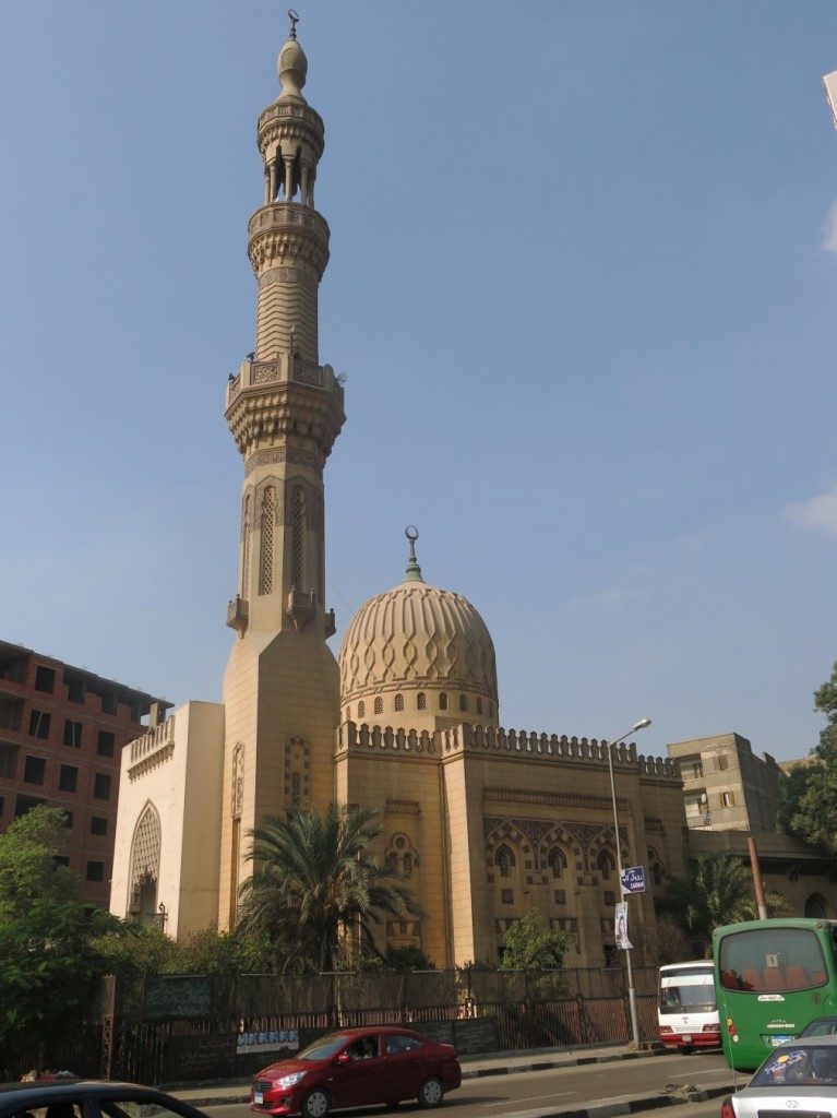
Khālid Ibn al Walīd mosque, situated in the location previously occupied by the Kīt Kāt Night Club, the square still carries its name, Kīt Kāt Square (Tadamun, 2015)
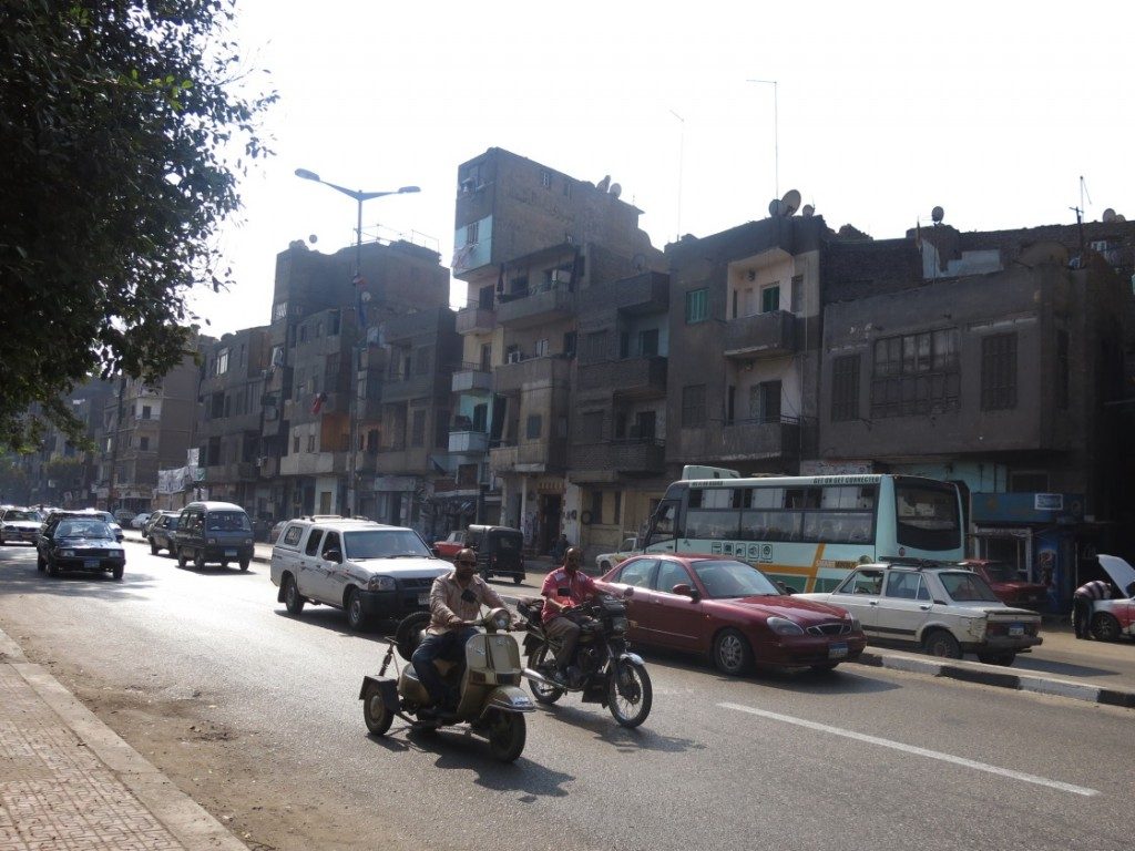
The Nile corniche from the Kīt Kāt direction has modest residential houses a few stories high, contrary to many other areas where the waterfront is invaded by high rise towers. On the ground floors are grocery stores, car repair workshops and simple crafts shops. (Tadamun, 2015)
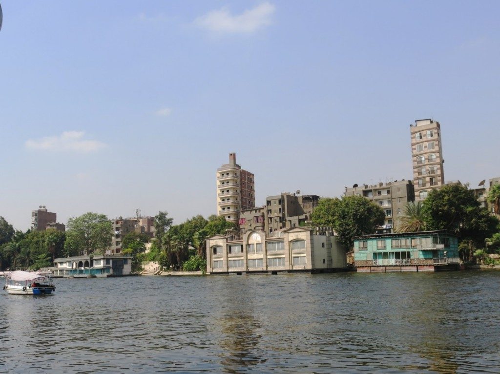
House-boats on the Nile in Imbāba; residential houses, wedding halls, restaurants, and simple, quiet hotels (Tadamun, 2015)
The Nile embankment, beyond the row of residential houses, is occupied by several governmental buildings, the most important of which is Imbāba police station, standing in the same place since it was built in the beginning of last century south of the Imbāba Bridge. Today it resembles a fortress after surrounding it with concrete blocks used to create a wall of protection around sensitive buildings such as police stations, ministries, and the embassies of powerful states. This has become a distinctive modern feature in the streets of Egyptian cities. In front of the police station stands the river-bus station, which is crowded during daytime by large numbers of youths who use the bus to cross to Zamālik. Next to the police station, lies Trolley Street, an important entrance from the corniche which leads us to the heart of Imbāba, running parallel to the railway until it reaches the Trolley Square. This square was the main terminal station of the trolleybus (electric bus) which previously travelled along the streets of Imbāba, but have since been decommisioned. Between the police station and the square we see many distinguishing landmarks such as Imbāba central telephone office, the train station, and a cultural social center for the residents, that has several football fields and billiard tables that the youths in the area rent to spend their leisure time. Behind the police station lies the mosque and dargah (shrine) of Sheik Isma`īl, surrounded by Kafr El-Sheikh Isma`īl and the Imbāba Island areas, which are not much different from the rest of the old areas of Imbāba: narrow streets with old houses built using traditional methods, either out of stone or mud bricks and mortar, and other new ones built out of concrete and red brick. They are for the most part three or four floors high, while the width of the street sometimes does not exceed two meters. The streets are completely devoid of lighting and paving, with the exception of a few streets that the residents illuminate with lanterns hung on the façades of their modest homes. The area also has many deserted houses, which cause several problems for the residents as those houses are in danger of collapsing due to dilapidation and neglect. This would adversely affect neighboring buildings. Additionally, the residents sometimes use the deserted houses as rubbish dumps, which could cause fires that would be difficult to control because the closely packed houses and narrow streets prevents fire engines from reaching the site of the fire. Moreover, the areas of old Imbāba suffer from bigger problems compared to neighboring areas; sometimes the streets flood with sewage water and the residents cannot move around, as the ground becomes muddy. They are sometimes even forced to wade through the sewage water. The demographics also vary; some residents are destitute, or are day laborers in the informal sector, while others own workshops or shops. Also among them there are those working in prestigious professions such as physicians, engineers and lawyers. The residents regard the inherited, strong social relationships between them as a huge advantage; if you are one of the residents of the area, it is impossible not to be known by each and every individual there, they would even know the details of your work, your family life and your relatives. This makes residents feel safe within their area, as they are able to monitor strangers and their movements, and determine whether or not these are to the benefit of the area or otherwise.
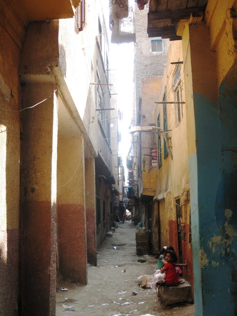
The streets of Sidi Ismail, after the residents had demolished their old, rural mud houses, and built in place higher concrete buildings in the same narrow streets. (Tadamun 2015)
Tir’at al-Sawāḥel Street is the main street that passes through this area. It starts at al-Sūdān Street, where the Imbāba courthouse – formally the North Giza courts complex- is situated on the corner, and terminates at the Trolley square on the other end. There are many informal areas on both of its sides, which began as huts of Upper Egyptian migrant families, then developed and expanded to form a group of streets following the same pattern as `Abd al-Na`īm street (`Izbat El Ṣa`āyda) such as al-Ṭanāni, Bayūmi Salām, Tawakol `Asrān and others on the opposite side of the street. The buildings range from four and five stories in height and have been built within a short period of time during the 1950s and 1960s according to the current residents who also claim they were built by the same building contractor, which is the reason they all have the same design, divisions and distribution of rooms. Most of the inhabitants of those houses are the owners themselves or their offspring. The proportion of rented flats in these areas is low, however, there is a small number of tenants with rental contracts according to the new leasing system, who mostly live in newly built houses which reach a height of eight to ten floors. These are still few in number and are located at the edges of the area. The majority of streets in these areas are inhabited by relatives and kinsfolk – that is, individuals coming from the same locality. El Ṭanānī street for example is well known for the presence of a large Nubian community in the area; a single street could be inhabited entirely by the members of one extended Nubian family, with no outsiders. The same applies to the Upper Egyptians who have populated and inherited `Izbat al-Ṣa`āyda. Those areas have a variety of closely associated social classes. They are neither very rich nor too poor, but there is, of course, disparity in income levels as well as the level of educational and cultural backgrounds – which are considered class related issues in Imbāba and in the other regions of Egypt – as well as origins, ethnicities and religions. Speaking with the residents, they talked about tolerance and exemplary coexistence between the various groups. They said that the Upper Egyptians and the Nubians have formed a cohesive, loving society, despite the fact that the members of one ethnic community – whether Nubians or Upper Egyptians – marry only from their own community. They never mix their genealogies and to this day a lot of families take this matter seriously and strictly. They also spoke about the supportive relationships that exist between the wealthier groups and those struggling financially in various situations, as well as the inherited social awareness which forms strong relationships that maintain its cohesion in times of crises. They also told stories about dealings between Muslims and Christians in which sensible words about national unity and coexistence predominate. These areas don’t offer employment opportunities, with the exception of some small projects such as coffee shops, pharmacies, grocery shops, herbalist shops, other sundry shops and workshops. These shops are run by and staffed by their owners, and they do not provide employment opportunities except for a limited number. Most of the residents go to work in other areas in Imbāba or in Greater Cairo generally.
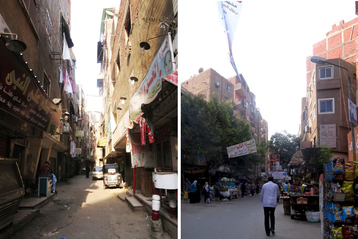
Right: The famous `Abd al-Na`īm Street in `Izbat al-Sa`āyda. Left: One of the side streets in `Izbat al-Sa`āyda area. (Tadamun, 2015)
At the heart of this area, on the right side of Ter`at al-Sawāḥil, the Swiss Club occupies one of the historical palaces, which was most likely built in the first half of the last century. The residents claim that it used to be one of the residences of King Farouk. Years ago it became the premises of the socio-cultural club affiliated to the Swiss Embassy, which embraces many cultural and social events and activities for residents of different parts of Cairo and Giza. Residents know it well, but not many of them frequent it nor do they relate to it – for them it is not a suitable place for them or they are not suitable for the place.
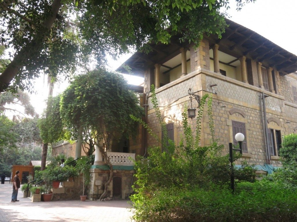
The Swiss club, a socio-cultural center that hosts middle class weddings in its open garden; it is distinguished by its classy restaurant, and sports and arts activities for children. Most of its patrons are expats in Cairo and people from the middle class, not many of Imbāba’s residents visit the place. (Tadamun, 2015)
On the right hand side of the second half of Ter`et Al-Sawāḥil Street, there is the `Azīz `Izzat housing development, which consists of governmental public housing blocks built on the land which, for many years, had been occupied by the large camel market. The husing development is characterized by relatively wide streets and good lighting with housing blocks of the the same design. Most hosuing blocks are dilapidated and lack basic maintenance of their facilities, yet they remain in a comparatively good condition compared to the surrounding areas. Despite the fact that these government housing blocks are planned and of better physical conditions than many other areas, most of the residents of different areas of Imbāba – even residents of al-Munīra al-Gharbiyya who are stigmatized as poor, violent and criminal – believe that `Azīz `Izzat housing is one of the worst areas in all of Imbāba. There is a belief that drug trade is widespread there with its residents lacking a sense of security. Other features that characterize the area of `Azīz `Izzat housing is the ceramics market, a vegetable market, and a school district, which includes Imbāba Military Secondary School, two secondary schools (for boys and girls), two schools for commerce, and around five schools for primary and preparatory education. There is also another school district in al-Salām street, next to the Swiss Club, and two primary schools in Ter`et al-Sawāḥil street. The Shorbagī factory, the historical factory which was mentioned previously, lies at the end of Ter`et al-Sawāḥil street; there is also an empty plot of land there, which the residents know as “The Porcelain Factory”, because a large porcelain factory had been located there. It was turned into a warehouse after it was closed. The residents tell us that the land is earmarked for constructing new houses and it is also rumored that a large empty plot of land at the end of the factory fence, next to the fire station, will be used for the same purpose.
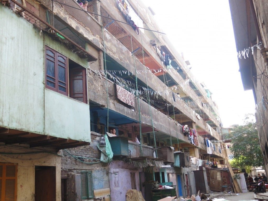
The poor live in poor homes; they do not have enough money for the maintenance of their homes, they do not have the luxury possessions to decorate them, and cannot afford the cost of a flat so they end up dividing the flats into smaller units, where more than one family live in the same unit. This photograph shows one of the recurring government housing patterns within `Azīz `Izzat housing, where there is poverty, urban and color deterioration (Tadamun, 2015)
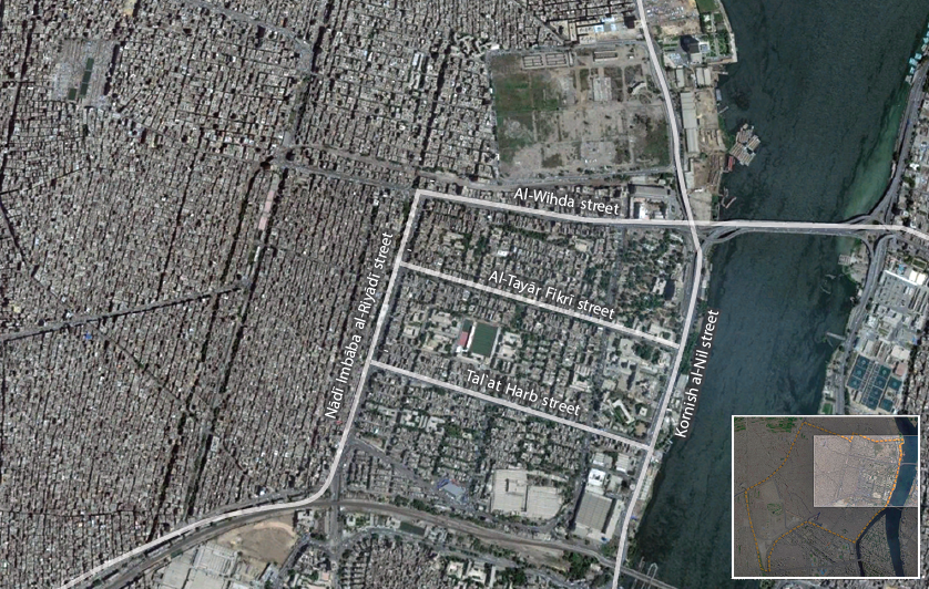
The towns of laborers and employees, houses of the middle-class, the best environment in Imbāba and least densely populated.
Behind the railway line and its distinctive bridge along the corniche, lie the residential towns, across the Nile from Būlāq Abu al-`Ilā. Those residential towns, which had been entirely planned by the government in the 1940s and 1950s, housed laborers and employees who passed the flats down to their educated, middle class sons. Their main entrances are from the corniche, and they are considered the best areas in Imbāba, from the point of view of the residents. Their condition has certainly deteriorated due to the mismanagement the area suffered from, like all other areas of Imbāba. However, their streets remain the widest among the streets of all other areas of Imbāba, with a good proportion of greenery, and building heights appropriate to the widths of the streets – albeit higher than planned. The third entrance to Imbāba from the corniche is besides the entrance of Kīt Kāt Square and that of Imbāba police station – this entrance takes you to the heart of the laborer’s residential town by way of Ṭal`at Ḥarb street. At its center is the Foundation Stone Square. It was said that the foundation stone placed by Gamāl `Abd al-Nāṣir to inaugurate the al-Taḥrir Town was at this spot. Ṭal`at Ḥarb street separates the laborer’s town from al-Taḥrir Town. At its center is “El Prince”, the most famous restaurant in Imbāba that specializes in traditional Egyptian meals – it enjoys wide acclaim and receives clients from several areas outside of Imbāba from all over Greater Cairo. The entrances on the corniche side continue with al-Ṭayār Fikrī street then al- Wiḥda street. Those are tree lined main streets, surrounded by a uniform network of side streets and buildings that are in a relatively good condition as well as services, such as Imbāba ambulance unit on Sa`ad Zaghlūl Street in the laborer’s town, and an ophthalmology hospital on al-Ṭayār Fikrī street in al-Taḥrir. Al-Taḥrir town is also distinguished by a school district. Originally it was one primary school called “al-Taḥrir School”, but over time it was sub-divided into eight smaller schools, among them Nile Schools, Refā`a al-Ṭahṭāwī, `Alī Mubārak and others.
The residents of these towns consider that their towns represent civilized Imbāba. They talk with an obvious nostalgia about the good quality of life in those towns in the past, and how those towns represented Imbāba – as they had known it – but that over time it had deteriorated like other areas. They remember that all the surrounding areas were agricultural land. “al-Wiḥda street was constructed, followed by Zakī Maṭar street and al-Gami` street and then the whole area became built-up,” one of the residents of the area told us. He also told us that with the increase in unplanned construction or “slums,” according to him, many of the prosperous people, who were able to save enough money to be able to move to better areas, left.
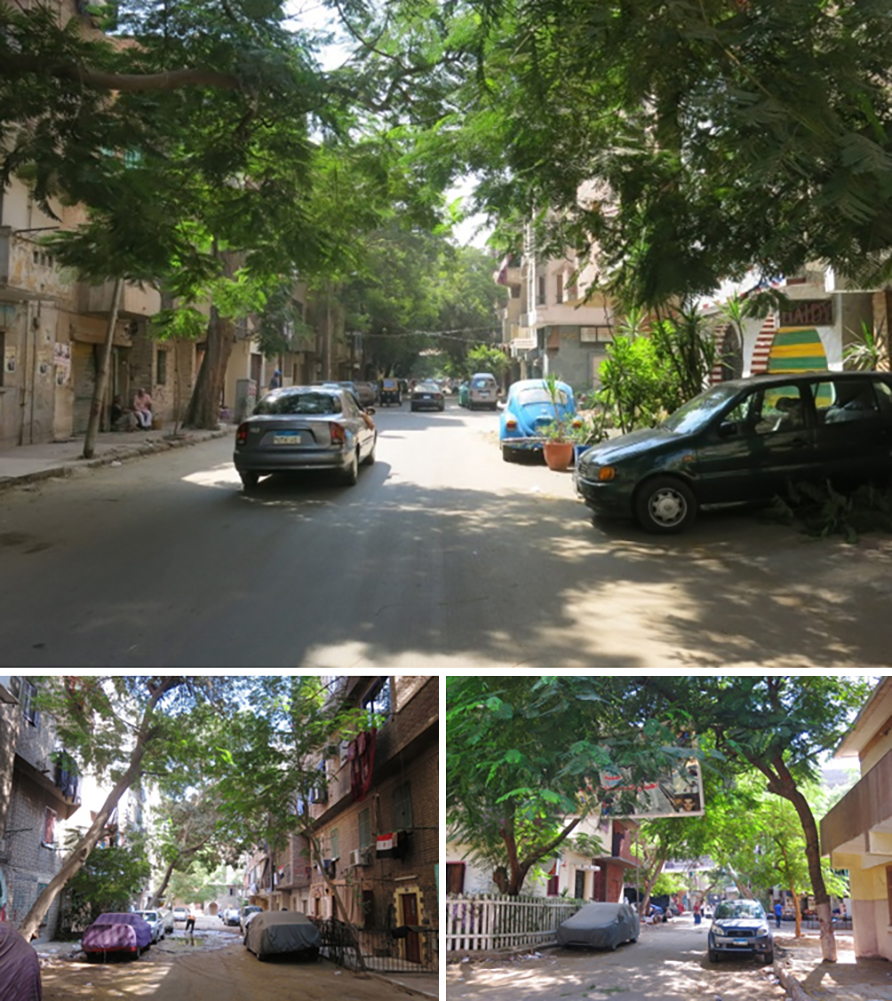
Laborer’s town and al-Taḥrir town, the planned areas for the middle class in Imbāba. Above: al-Ṭayār Fikrī street, the main street in al-Taḥrir town; above left. Below right: al-Mahdī street in Laborer’s town. Below left: al-Safa street in Laborer’s town (Tadamun, 2015)
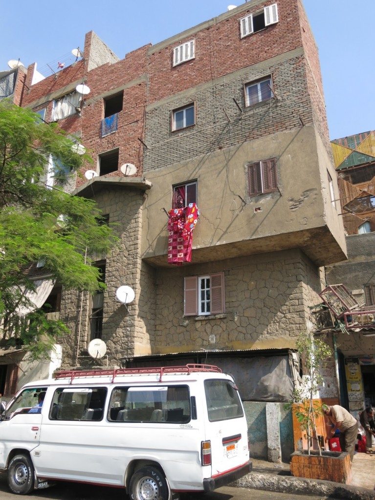
The informal building of additional floors in Laborers town, the original building with its stone façade and the higher floors built in brick are apparent. (Tadamun, 2015)
Imbāba’s Nile embankment is characterized by several landmarks and important buildings such as the Government Printing Press and the historic home of the engineer who was responsible for moving the Imbāba Bridge. The corniche strip is also occupied by a number of national institutes, such as the Hearing and Speech Institute, the National Institute for Motor Neuron disease and also the Imbāba Fevers Hospital, which serves several areas outside of Imbāba. The residents consider it the most important hospital in their district and always go there for treatment. They also consider it a landmark preceding another important entrance of Imbāba, namely al-Wiḥda Street, which is a continuation of al-Sāḥil Bridge that starts at Roud al-Farag. The importance of Al-Wiḥda Street lies in the fact that it is the main street leading to al-Būhī Square and al-Būhī Sstreet and from there to El Kawmiyya street which in turn leads to the Ring Road. Its extension – called “Imtidād al-Wiḥda street” – goes into the center of al-Munīra al-Gharbiyya and intersects with al-Oqṣor atreet, one of its most important streets. It is the entry point that leads you to a network of main streets within the depths of all Imbāba.
After al-Sāḥil bridge lie the big grain silos – officially North Giza Flour Mills, and facing it on the Nile bank is a plot of land owned by the Maritime Shipyard, which is now closed. The residents expect that it will be replaced with a park or another recreational outlet on the Nile. Finally, there is the urban legend of the “Chair Factory”. Eventhough the factory stopped manufacturing chairs, was shut down and demolished and al-`Arabī Residential Towers have been built in its place, the site is still known to residents as the Chair Factory. The name extends to encompass the street as well, known as Chair Factory Street, although officially it is called Maḥmūd Sālim street. Although it had been demolished, it is today still one of the most famous factories in Imbāba, and it has become a symbol for mockery that has become wide spread, not only locally but also internationally. The threat “behind the Chair Factory” became the most famous threat for humiliating opponents.
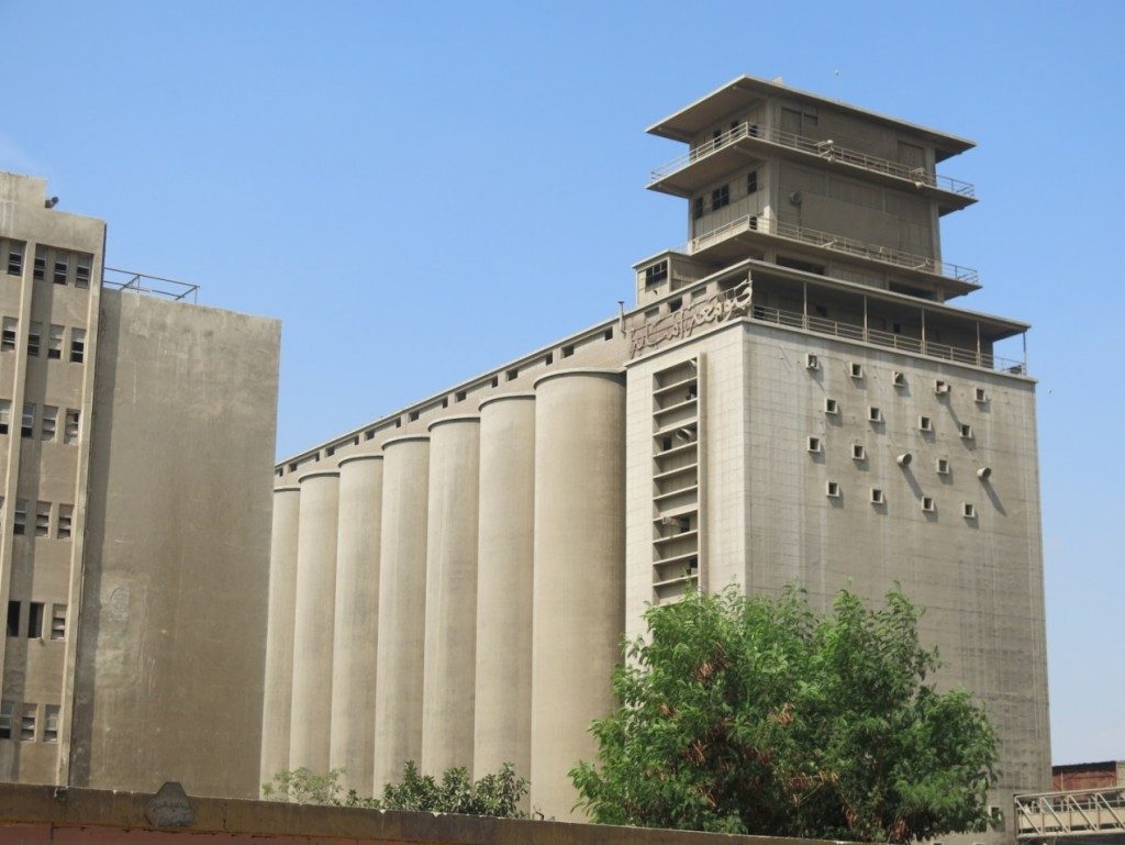
Imbāba grain silos – officially North Giza Flour Mills –on the corniche after al-Sāḥil Bridge – for those coming from the direction of Giza – the entrance is on al-Wiḥda Street in Imbāba. The grain silos own a railway line passing through Imbāba to transport the grains, (Tadamun, 2015)
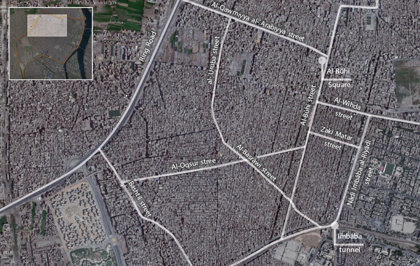
Imbāba is stigmatized as being unplanned and violent, Imbāba the neglected, crowded, and controversial district; the areas of al-Munīra al Sharqiyya and al-Munīra al-Gharbiyya.
The third area in our tour represents the most controversial Imbāba, the area with the highest population density, and the most crowded; it has the narrowest streets and the poorest services: al-Munīra al-Sharqiyya and al-Munīra al-Gharbiyya. The areas overlap, and it is difficult to define clear boundaries between them. They were all built on agricultural land and expanded at an enormous rate during the last three decades. The divisions of agricultural basins that were essentially the basis of their casual, unauthorized planning are still apparent in the fabric of its physical plan. The houses are crammed together and the streets formed from filling the canals – the large canals became main streets and subsidiary canals between basins became side streets.
Al-Munīra al-Sharqiyya is connected to Trolley and Ter`et al-Sawāḥil streets through the Imbāba tunnel (or al-Munīra tunnel). At the beginning of its entrance, past the tunnel, there is the most important transportation hub within Imbāba with bus and microbus terminals, which transport Imbāba residents to many districts in Giza and Cairo. Additionally, there is a market where vegetables, fruits, clothing and simple goods, are sold in modest shops and kiosks or on carts. After the tunnel there is Imbāba Sports Street, which separates the towns of laborers and employees from East Munīra. According to the words of some of the Imbāba residents, this “separates the high-end areas from the slums”. Imbāba Sports Street intersects with the important streets coming from the corniche so that they end at this point, namely Ṭal`at Ḥarb, al-Ṭayār Fikrī and al-Wiḥda streets.
Al-Munīra al-Sharqiyya is the area between Imbāba Street and the parallel al-Būhī Street. An important residential area, its side streets are relatively quiet and have a reasonable number of trees. The streets are not completely paved, but the width of the streets is suitable for the average heights of the buildings. Imbāba Sports Street is considered an important commercial street, where shops sell clothes, shoes and electrical appliances, and similar to downtown as it is a wide street offering many services. On the other hand, al-Būhī Street is a noisy, crowded street, crowded with various means of transportation. A railway line runs along its center, which was, decades ago, designed specifically to transport wheat to the silos. It is also the street chosen by the Egyptian government for the new metro line, which will traverse the middle of the street. In the center of its square there will be a metro station called “Al-Būhī Station” that will become a starting point for those travelling to surrounding areas of Imbāba by metro which is currently under construction.
Leading into Al-Būhī Street are al-Oqṣor and al-Baṣrāwī streets, the most important streets in al-Munīra al-Gharbiyya. An area of international renown, it is where the 1990s conflict, with all its tangled factions, took place. Nowadays, al-Munīra al-Gharbiyya has become more crowded with the number of its residents increasing day by day. Today, it has the highest population density by a large margin among all the areas of Imbāba. One of the residents commented that “the streets are narrow, the buildings reach the heights of ten floors, built on 100 square meters and divided into two flats on each floor,” exemplifying the high population density in the area. The area suffers from apparent neglect; most of the streets are not paved, and residents complain about problems with sewage, water supply and the absence of schools and hospitals. That is the reason why private and informal sectors play a major role in the lives of the residents, who depend on private schools, clinics and nurseries, which are often located in residential buildings. The informal markets constitute the backbone of the lives of residents here, as they provide their basic needs of food, household utensils and the like. The religious establishments also play an important role in offering educational and health services and many people depend primarily on the dispensary of a-Gam`iyya al-Shar`iyya al-Islāmiyya or the church dispensary. The development of al-Munīra al-Gharbiyya, as we mentioned, was formed around the main streets which were originally canals. Al Munīra al-Gharbiyya includes many areas that are known to the residents butwhose boundaries are difficult to define as they grow around the intersecting main streets, the most important of which are al-Baṣrāwī, al-Oqṣor, and al-`Orūba, as well as the areas of Benī Mohammed and `Izbat al-Moftī amongst others.
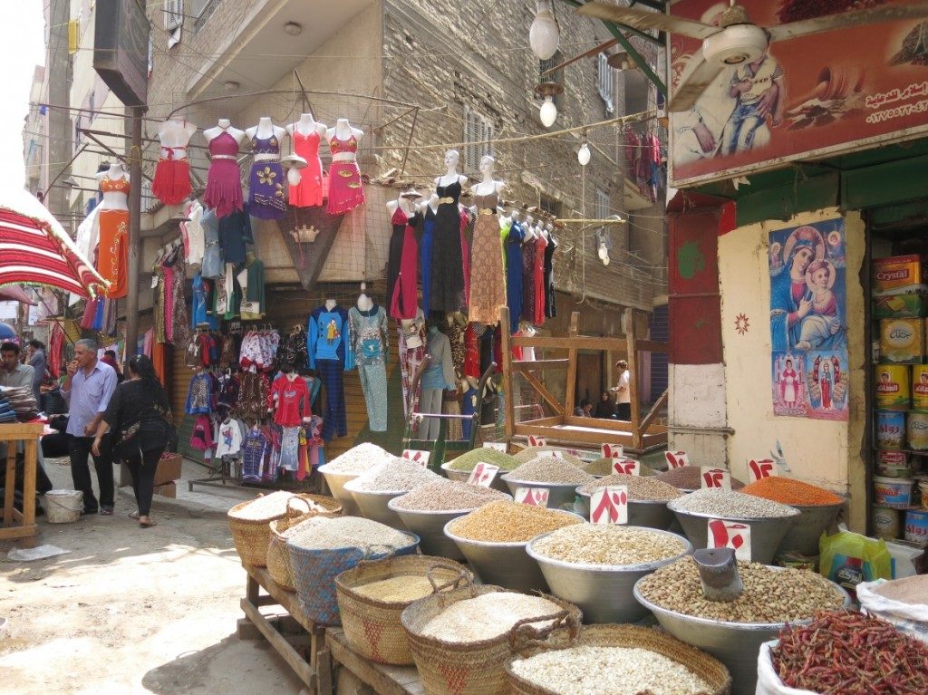
Shops and mobile as well as fixed commercial activities, are landmarks for many of the main streets of al Munīra al-Gharbiyya. The picture is from al-Baṣrāwī Street. (Tadamun, 2015)
The residents also have various origins, and several stories are frequently told about those origins. Many of them agree that the first people who established most of these areas came from Upper Egypt, mainly from the Asyūṭ governorate. Minority communities were also formed within these areas, such as the gypsy community in `Izbat al-Moftī who had settled there during their wanderings, and formed their own community. This community suffered, and still suffers, from the stigmas associated with gypsies as in most parts of the world. Imbāba residents also told us that the highest percentage of Christians in Imbāba is found in the areas of al-Munīra al-Gharbiyya, such as Benī Mohammed and al-Baṣrāwī. This is reflected in the concentration of churches in these areas and the religious icons in the form of drawings and models which are proudly displayed, and characterize many of the houses and streets. In fact, the religious symbols, whether Christian or Islamic, represent a significant element in the appearance of this town, as they give the visitor the impression that there is a contest to advertise the religious identity of a house or street in the form of more beautiful, larger, clearer and more expensive drawings and phrases. On the main streets the christian and muslim symbols are found side by side in remarkable peace.
Al-Qawmiyya al-`Arabiyya Street forms the boundary of Al-Munīra al-Gharbiyya from the north, and it is the main street that separates the North Giza district (Imbāba) from al-Warrāq district. The residents of the surrounding areas describe it the as “the most important street in Imbāba,” because it represents the main traffic artery in their town. It is a wide dual carriageway and each direction has three lanes in addition to parking spaces on both sides. It is jam-packed with commercial establishments and the height of residential buildings vary along the street, but from every vantage point you can see a set of towers which reach the height of fifteen floors. At the end of the street we find the tunnel that crosses under to Bashtīl on the opposite side, and an entrance to the Ring Road. There is also a small park they call The Ring Road Park which the residents consider an important recreational outlet for the area on that side. In spite of that, the street suffers from neglect, because it is divided between two administrative districts, with each holding the other responsible for street improvement. The Ring Road completely encircles al-Munīra al-Gharbiyya on the west side and the residents themselves built more than one pedestrian stairway to be able to reach the Ring Road. This, in turn, has created unauthorized stops for the transport vehicles used by Imbāba residents to travel to various parts of Cairo.
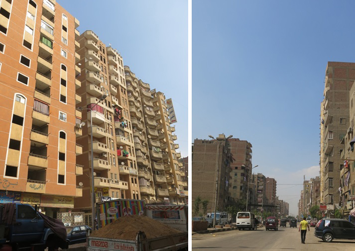
Right: Al-Qawmiyya al-`Arabiyya Street. Left: Residential towers in al-Qawmiyya al-`Arabiyya Street. (Tadamun, 2015)
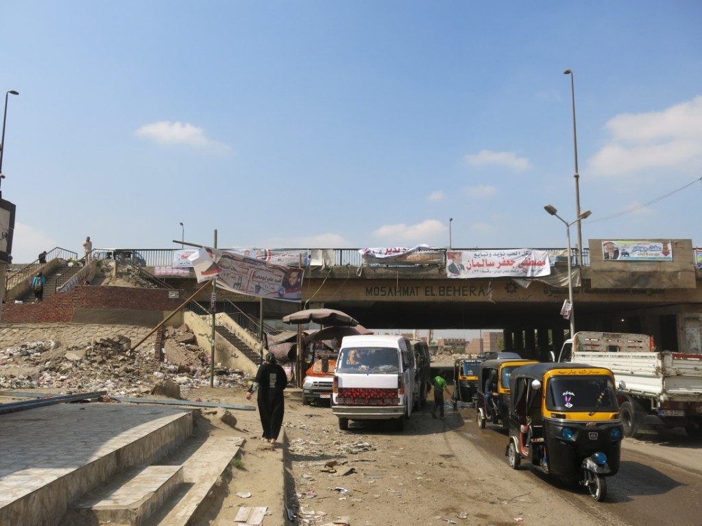
The tunnel below the Ring Road leading to Bashtīl, and the stairway which leads to one of the important traffic points on the Ring Road, connecting, through the microbuses, several areas around Greater Cairo. (Tadamun, 2015)
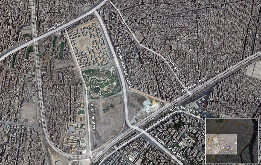
Formal and informal: The project of Imbāba Airport housing, to its south is al-Mohandisīn district. Ahmed `Orabī Street extends in the form of a major traffic artery that connects to the ring road north of the housing project. To the west of the formal housing project is informal `Izbat al-Maṭār, and to its east is Madinat al-Amal, Bashtīl Street and the extension of al-Munīra al-Gharbiyya.
Giza Park, which is a part of the development project as well, is considered the biggest and most important park in the area. The residents visit it, especially during feasts and religious festivals, and many consider it a wonderful addition to their area. It is a beautiful, affordable and adjacent destination where a family can spend its holiday. With its large green areas, and games for children, the park affords them the opportunity to run and play in a way that they are normally deprived of in their areas crowded with concrete buildings.
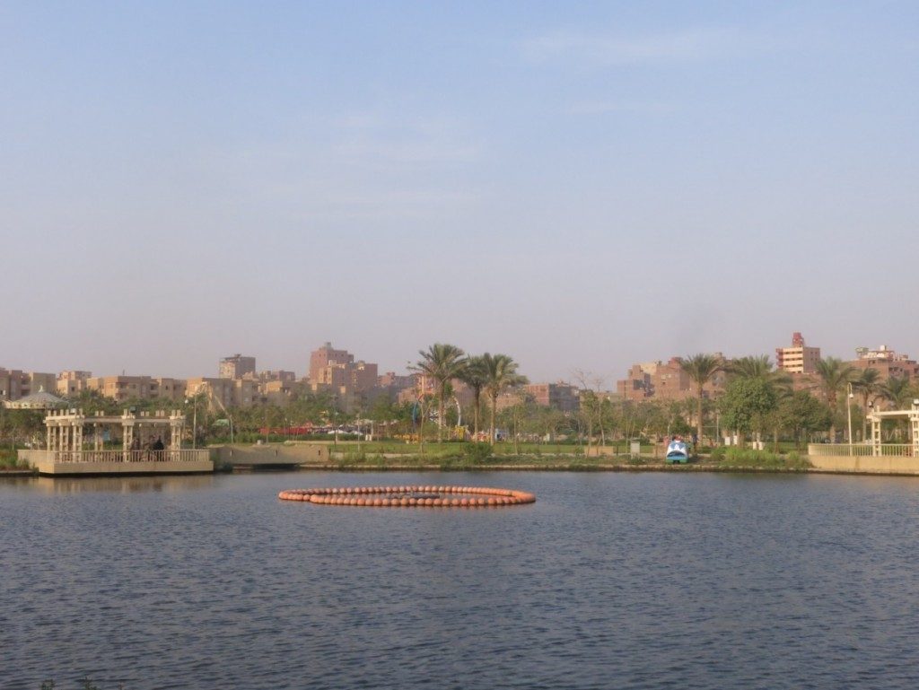
The Giza Park, vast green areas, some artificial lakes, restaurants, a theater and spaces designated for children to play makes an ideal park for the residents of the surrounding areas. The entrance fee is 10 Egyptian Pounds (Tadamun, 2015)
Next to the park is a large governmental residential project, with the construction of most units completed, but which has yet to be opened. The five-floor buildings have uniform designs and colors with wide pedestrian passages between them, however the features of life there – the houses, public spaces, and services – are not yet apparent.
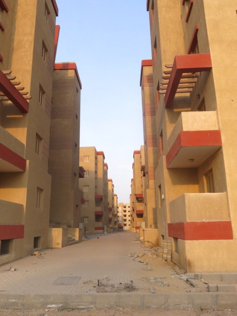
Pedestrian passages between the buildings of the new residential project, the final finishing work is nearing completion. (Tadamun, 2015)
`Izbat al-Maṭār, which is the area facing the airport, park, and the official residential project, is an informal community, not much different from some of the areas in al-Munīra al-Gharbiyya, but the conditions of the residents and the buildings are a little more modest. Ultimately, it is a community deprived of many services and facilities, which was built by the efforts of the residents themselves. The streets are narrow and the concrete buildings were left without finished façades as the finishing is considered an extra cost and a luxury that residents of such areas cannot afford. The residents do not know how they will benefit from the huge development project planned in their area, however, it seems that most probably they will not benefit at all, except from whatever employment opportunities which may arise or the recreational outlets planned in the area. However, many of them fear that the project might negatively affect their lives when the value of the land they live on increses upon the completion of the project. In that case eviction (both direct and indirect) becomes a clear and present danger.
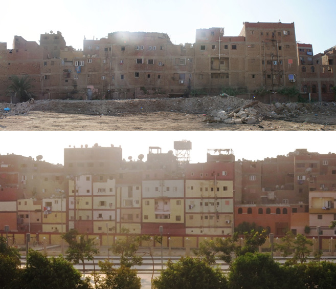
The buildings of the `Izbat al-Maṭār facing the Giza Park, after the Central Agency for Reconstruction painted the façades, in order to appear nicer to the visitors of the park. Those “upgrading” efforts did not take into account the real needs of the residents concerning the services and the facilities of the local administration.
Above: The buildings before being painted. (Tadamun, 2013) Below: The buildings after being painted (Tadamun, 2015)
The problems of Imbāba
Local administration crises
The problems of Imbāba are varied in the different areas which in itself is a problem that faces many areas in Egypt. This wide geographical area, that falls under the authority of a single agency for local administration (the northern Giza district), includes areas that have disparate problems and concerns. It is difficult to monitor and deal with them effectively, and to develop plans and participatory budgets to meet their needs without dividing the local administration into smaller administrative units. The problem is not limited to the grouping of all these areas in one district, the lack of clear criteria for apportioning expenses to smaller areas or the lack of mechanisms to ensure the residents’ participation. Even the location of their own district council does not fall within their area at all, but is located beyond this huge area in the al-Agūza district. Consequently, this makes the residents feel that this council is not theirs and that it does not care to open its doors to them, or at the very least receive their complaints and requests.
On asking samples of residents in the various areas, they all agree that there are many problems relating to the misconduct and corruption of the local administration and the absence of monitoring or possibilities of holding local officials accountable to the residents themselves. In some areas the residents have given up hope that the government will put efforts into solving the problems of the dilapidated infrastructure, especially the sewage networks. Many areas in Imbāba suffer from shortcomings in the sewage system that could amount to the collapse of buildings in some areas. In 2011 the residents of al-Imām al- Ghazālī Street in al-Munīra al-Gharbiyya experienced a severe subsidence of the street due to the collapse of the sewage network, which affected the foundations of the buildings and led to the collapse of several buildings and the fracturing of others. The residents responded to this crisis by holding protests in front of the Giza governorate building and demanding through the media that their lives should be protected from the danger. The problem of al-Imām al- Ghazālī Street led some local engineers living in Imbāba to voluntarily study the situation. They identified foci of underground water which must be injected with concrete. This is an extremely expensive solution that the residents cannot afford. They, additionally, stated that the sewage networks have to be replaced because they are old, decrepit and cannot cope with the current population density. The basements in `Azīz `Izzat housing are not in a better condition. They were completely flooded with sewage, which threatened the structural safety of the buildings. According to the members of the People’s Committee, the problem has recurred over the past years in the areas of al-Masābik, Beni Mohammed, al-Qawmiyya, al- `Orūba and Al-Munīra al-Sharqiyya.
Most of the areas of Imbāba also suffer from waste management problems. The lack of an effective waste disposal system least most residents tend to to dispose of their rubbish on the streets. The rubbish filled streets attracts insects, cats and dogs, sheep and egrets which graze there in the middle of the city streets. The residents of the different areas were in agreement about their discontent with the lack of rubbish collection from the streets, and they felt that a solution for this issue must be the priority of the District and at the top of the agenda of any development project that involves Imbāba. This demand even found a place in the midst of major political protests in 2011, when the youths of the Popular Committee for Defending the Revolution in Imbāba, together with a group of residents, arranged a protest to put pressure on government bodies to solve the waste management crisis under the title “Throw Your Rubbish in front of the Governorate”. As expected, the officials faced the discontent, by accusing the protestors of conspiracy rather than by discussing the problems with them to find practical solutions in which citizens cooperate with government bodies to resolve the mounting crises. Today, the rubbish problem remains unresolved. In al-Munīra al-Gharbiyya there are no rubbish collection services from the houses and the residents carry their rubbish themselves to specific places on the main streets such as al-Baṣrāwī Street and al-Oqṣor Street, and leaving it in the center of the street until the District’s cars remove it. One of the residents of al-Munīra al-Gharbiyya said “The Government is incapable of dealing with high population density; they come every few days to remove the rubbish that had piled up. They are supposed to come twice a day.” While in the areas of `Izbat al-Sa`āyda and al-Ṭanānī an informal “rubbish collector” removes the rubbish from houses in return for a prearranged monthly payment, some residents claim “he collects the rubbish and throws it outside on the street [meaning Tir`et al-Sawāḥil Street] and the District’s employees remove it at night.” In the areas of Old Imbāba, the District announced a few months ago the start of the implementation of a new system for waste disposal that depends on a new partnership between the District and small Egyptian cleaning companies (after failing to contract a foreign company). But the crisis has not been resolved yet, as the companies receive their pay from the District but fail to provide the service to the residents, because there is neither a direct relation between the company and the residents nor is there a mechanism for filing grievances. This demonstrates the floundering of the local government system that follows the methodology of trial and error and then repeats the same error, learning neither from local experiences nor the experiences of similar cities in the world.
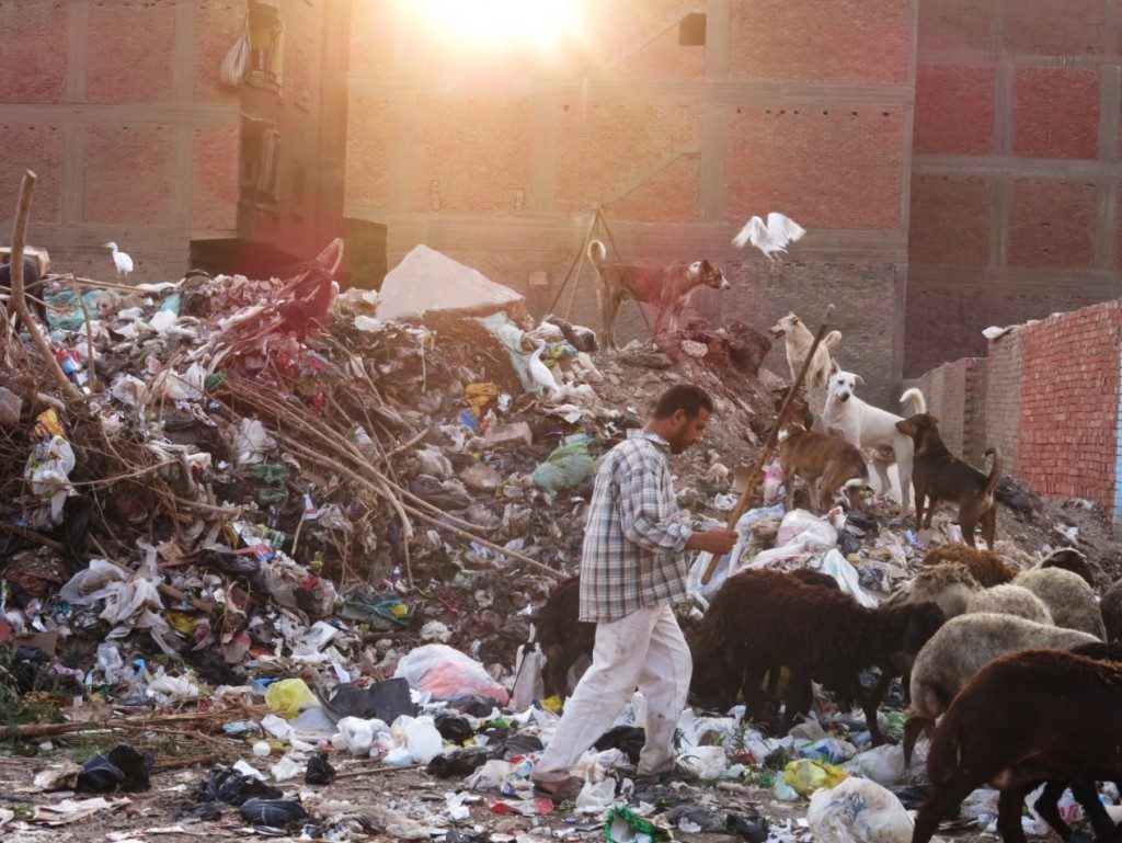
The piles of rubbish have their customers as well, the shepherd, his sheep, dogs, and egrets. Photographed at the area of `Izbat al-Maṭār, neighboring the Giza Park, Imbāba (Tadamun, 2015)
The absence of public transport from Imbāba, and the difficulty of moving around within Imabāba is one of its most pressing problems. As public transport buses travel only on the main streets around the periphery of Imbāba but not within it, the area entirely served by a private or informal transport network of microbuses, tuk tuks and pickup trucks. Their routes are so short that an individual may be forced to move between three or four different means of transport to get from one place to another within Imbāba itself, even before starting the journey outside in Greater Cairo. Residents remember the trolleybuses, which are buses powered by electricity obtained from overhead wires that had fixed routes which transported the residents. These had been decommissioned and closed years ago. Also, public buses used to go up to Tir`et al-Sawāḥil Street, but their route had been changed and now they travel along the corniche only. Additionally, many complain about the congestion and lack of traffic control in the district. With the exception of the corniche and its important buildings not a single policeman is found within Imbāba to organize traffic, in spite of its large area, which causes widespread chaos in the streets. However, many of the residents consider that Imbāba is a central area in the heart of Greater Cairo where different modes of transportation are available. There is also great hope that the new metro line will make people’s daily lives and mobility within the city much easier.
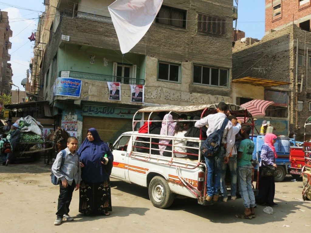
In addition to the tuk tuks and microbuses, pickup trucks modified to transport people are one of the forms of transportation used in some parts of Imbāba. The photograph is of Baṣrāwī Street in al-Munīra al-Gharbiyya. (Tadamun, 2015)
In general, residents of Imbāba complain about the lack of public services and their poor quality. For example, there are insufficient health facilities in Imbāba that could cope with the number of residents at reasonable prices. Also, the Imbāba General Hospital experiences complaints of neglect, the poor health services provided and the inadequacy to meet the health needs of the residents. In addition, the central hospitals on the Nile do not serve the people of Imbāba only, but are considered national, because they serve the entire Republic. Residents had previously been promised that a unit for trating emergencies will be constructed but the project has not been implemented for unknown reasons. Residents of Imbāba also suffer from a lack of educational services. Despite the large number of schools in Imbāba it is not sufficient for the residents as the density reaches more than 80 children per class. Additionally, schools are concentrated in areas closest to the corniche, while closer to the ring road the residents suffer from a complete lack of schools. In most cases their children are not accepted in schools in other areas of Imbāba. Unfortunately, they are not considered a priority on lists that are already overcrowded.
The issue of classification and stigmatization
For a long time Imbāba has been described as unauthorized or informal in books, the media and even in the official documents of the government and major international organizations operating in Egypt. This description informed much of the analysis and media discourse, firmly establishing the social stigma attached to the area’s residents and the government’s negligence of their needs. These classifications have not only affected the area’s reputation, but have also contributed to confusing researchers and parties interested in monitoring and analyzing the reality of urbanization in general. The contemporary discourse often gave them wrong impressions, upon which analyses are undertaken and subsequently recommendations and conclusions are made, which are, of course, of no value. For example, we find that, in 2005, the researcher Mike Davis has pinpointed Imbāba as one of the largest mega slums in the world. According to Davis (2006) Imbāba, alongside `Izbat al-Haggāna in Cairo, rank as the seventh largest in the world in terms of the number of residents. With a population of one million residents, Imbāba is placed here in the same category with Kibera, Nairobi, Kenya, and Dharavi, Mumbai, India, in spite of the huge difference in the form and state of the construction, the nature of the facilities and the accessibility of services (Khalifa, 2011). In addition, describing the whole district as informal is inaccurate as many residents have documents to prove the ownership of their houses. Also, almost all of them are connected to public utilities networks, and pay water, electricity and natural gas bills on a regular basis. In any case, there is no definition in Egyptian law for informal settlements. The classifications specified officially are “unplanned areas” and “unsafe areas”, thus, is all of Imbāba classified officially as an unplanned or unsafe area? No.
In the report surveying and classifying unsafe areas in the Giza Governorate, issued by the Informal Settlements Development Facilities (ISDF) in 2013,9 only three areas in Imbāba were classified as unsafe, namely Gezīerit Imbāba, Ḥikr Tawakkul and Mīt Kardak, all of which are privately owned and represent the historic villages in the heart of Imbāba. They were assessed by the ISDF to be in “danger of the second degree” which, according to the standards of the ISDF, are areas consisting of houses built with leftover building materials, or on soil that is unsuitable for construction or areas with rundown and dilapidated buildings. Upon close consideration of the old Imbāba areas we find that most of the old mud buildings had been demolished and replaced with concrete buildings, and that the percentage of rundown buildings is small.Certainly, there are several problems in these areas which we have enumerated before, but the classification standards are still problematic; how can an entire area and not just a building or a group of adjacent buildings be classified as unsafe? The residents of these areas fear forced evictions and are wary of any stranger who carries out research about them. They inquire whether there are any planned development projects and whether they will be evicted from their homes that have been handed down over several generations. Some are worried that the government intends to take their land, as it is close to the corniche and will increase in value with the development of the corniche and its exploitation as an investment. Meanwhile, they do not see any attempts to improve the sewage networks or to pave the streets and illuminate them, for example, which are basic needs lacking in the district.
The other official document that classifies the areas of Imbāba is a study by the General Organization for Physical Planning10. The data about Imbāba states that the planned housing represents 90.5% of housing in Imbāba and that it does not contain unplanned areas by the definition of the Egyptian government with the exception of just 175 feddans out of a total of 3012 feddans, of which only 13 feddans are unsafe areas. Upon close exampination of the map and the locations of these areas defined by the study, we find that these unplanned and unsafe areas are all concentrated in Old Imbāba and the surrounding zone. The areas of eastern and al-Munīra al-Gharbiyya, `Izbat al-Maṭār and others in which unplanned construction took place, and which were built during the expansion of unauthorized areas during the 1980s and 1990s, are not indicated as unplanned areas in the report. The available data and maps raise many questions about the mechanisms of classifying the areas and the criteria for excluding some areas and including others in a statement such as this one, issued by the central government body responsible for setting the strategic planning vision for the district.
Another crucial issue is that these classifications do not really tell us anything about the actual urbanization of the area and the needs of the residents. These classifications do not tell us whether an area needs schools or not, or whether the residents of an area are poor or rich. The examples are endless; if we look at `Azīz `Izzat housing, which are houses planned and built by the government, we find that their condition has deteriorated and residents feel more insecure than in many other unplanned11 areas in Imbāba. The report of the GOPP does not add to our knowledge, nor to that of the decision maker, when it states that the areas colored in blue were built without being planned by the government – as is the case with 75% of the areas in Egypt. However, the report gives us the impression that the characteristics of urban poverty are general and include the residential areas where most of Imbāba’s inhabitants live, which is actually what we need to know, away from the classifications; just as we need to know that the green space per capita in Imbāba does not exceed 0.21 m2 which indicates that the majority of the residents are deprived of green spaces, trees, entertainment and sports associated with the parks. It, then, becomes essential to construct gardens like Giza Park in such a place, and several other parks whenever there is an empty plot of land here or there.
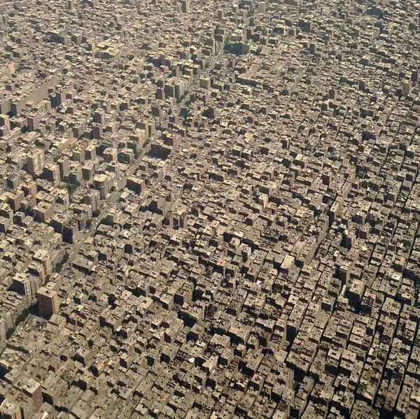
An aerial photograph captured by real estate developer Karim El Shaf’ei of the Imbāba district, showing the complete absence of green areas in some parts of Imbāba.
Developing Imbāba
Between 2022 and 2032 Imbāba will acquire a park overlooking the Nile as part of a comprehensive redevelopment plan of the Corniche. From an investment perspective, this will allow the creation of administrative buildings and hotels, and will also provide the area with an upmarket development on the vacant plot of Imbāba Airport. Wide avenues will be constructed with the intention of becoming new traffic axis hubs within the area to facilitate the flow of traffic. The unsafe areas will be “dealt with” as we are informed by the Strategic Development Plan for Greater Cairo. Some of the officials summarise the State’s development vision by suggesting that Imbāba will soon be transformed into “new Mohandesīn” as stated in an announcement by the head of the organization responsible for implementing the project – General Maḥmūd Maghāwrī, Head of the Central Authority for Housing.
Therefore, Imbāba’s urban upgrading is not just a vision being posed by the Tadamun Team, but is a reality whose implementation commenced a few years ago and continues under the title of “The North Giza Sector Urban Upgrading Project”. This project includes the redevelopment of Imbāba and al-Warrāq and is considered one of the major redevelopment projects recently adopted by the Egyptian Government with a great deal of attention and a large amount of its budget being devoted to it. The work has been ongoing for the past few years despite the upheavals and the political events which led to the cessation or cancellation of a number of projects and the modification of others. Since the discussions started in 2003, and through to the actual starting point when the Prime Minister issued a decree approving it in 2008, the completion of its first phase (opening some of its components during 2013 and 2014), and through to the recent decree by the Prime Minister (relating to a new phase of the project in April 2015), we find a great degree of consistency in the project’s vision. There is also consistency in the coordination between the various government agencies finalizing it in as close a form as possible to that envisioned by the original decision makers, urban planners and government officials.
In the following sections we will explain how this important project started, its fundamental components, the extent to which it fulfils the needs and ambitions of the residents, the ways it will impact their future and the proposed developments beyond this project.
The plans for the upgrading of Imbāba commenced when a Government decree was issued to develop the land devoted to Imbāba Airport which had become vacant following a decision to cease all flight activities in the airport and to relocate it to Sixth of October City. This Airport was constructed in the 1940’s for civil aviation training when the area was surrounded by fields and open spaces. Following the acceleration in the rate of urban development and the erection of high-rise buildings in the neighbouring areas, as well as the recurring accidents resulting in the deaths of some of the area’s residents between the 1980s and the early 2000s, it became essential to revise the activities on this plot. The plot occupies an area of 209 feddans of Imbāba and included runways and buildings of the Egyptian Aviation Academy which were also relocated elsewhere.
The General Organization for Physical Planning, a subsidiary of the Ministry of Housing, Utilities and Urban Communities was tasked with researching the optimal use for the land vacated by Imbāba Airport. A number of proposals were put forward. One of those was to build an educational complex; however, the idea was abandoned in view of the traffic congestion it may cause and the resulting concentration of services in one area. The second proposal was to establish a large public park along the lines of Al Azhar Park in Cairo in view of the total absence of green spaces in the area. This proposal was also abandoned for reasons relating to financial feasibility and because it did not address the residents’ dire need for basic services. Eventually, the decision makers settled on a comprehensive redevelopment project for Imbāba with the first phase being the re-designation of the Imbāba Airport plot. The second phase was to redevelop the rest of Imbāba with a comprehensive major road network, the creation of new traffic hubs and supplying the area with the necessary public services.
1. Imbāba Airport Land: What a vast vacant plot permits within an urban area
The availability of the Imbāba Airport plot and the desire to put it into use were the primary motives for this redevelopment project. Two hundred and nine feddans were to be transformed into a new urban centre; an integrated town with a variety of essential services and investment facilities to serve its residents and those of the neighbouring areas. The planning for this new urban centre was carried out by the General Organization for Physical Planning and the consultants that were selected by it. The General Central Development Authority (subsidiary to Ministry of Housing, Utilities and Urban Communities) was tasked with implementing it in 2009.
This city includes a public park which was completed and opened in January 2014. It was given the name of “Giza Park” and was introduced as a new “Azhar Park”. It was erected using Government funding but was then offered to be managed by private investors.
It also includes a multi-service hub which is currently under construction – this comprises educational and administrative establishments, open spaces and youth centres – which are to be housed in the re-designated Aviation Academy buildings as well as purpose-built new buildings. At present, building work is being carried out within this service hub.
The residential area contains around 3500 residential units with an overall floor area of 70-75 sq.m. per unit. A number of Government sources announced that these units would be used to re-house Imbāba residents who would have to be displaced as part of the re-development project. It will also contain shops, car parks and areas devoted to public utilities. The residential area is nearing completion but none of the units have been handed over yet.
The project also involved the construction of a highway passing through Imbāba, connecting downtown, Zamālik and Mohandesīn to the ring road circling Greater Cairo through the extension of Ahmed `Orabī road – the main road in Mohandesīn which is linked to the 15 May Bridge and which leads to downtown. This highway – Ahmed `Orabī Axis Road – was completed at a cost of LE 320 million and opened in October 2013.
The final element of the Imbāba Airport project is an investment zone, adjacent to Mohandesīn which explains its high real estate values. Work has not yet commenced on this phase and we do not have a clear picture as to what it might look like in the future. However, declarations by officials indicate that this investment project will aim to attract capital in order to defray some of the expenses of the rest of the project. This will be through a variety of commercial and entertainment projects such as shopping malls, cinema multiplexes and through administrative, medical and educational projects all with an investment rationale aimed at serving social groups undoubtedly of a higher order than the present residents of Imbāba.
2. Government Redevelopment of the remaining areas of Imbāba and El Waraq forming the North Giza sector
In addition to the opportunity that arose for the Egyptian government to develop a huge area of vacant land in the heart of the city with access to the ring road and adjacent to upscale areas, the General Organization for Physical Planning is working towards developing the Imbāba area through two further approaches:
The first approach is service oriented. It will be achieved through providing residents with services and amenities they are in dire need of through the establishment of 18 service centres. These will contain a number of schools, parks, youth centres and health care units as well as a hospital, a cultural centre, rescue services, post office and car parks. The project will utilize vacant plots in existence within Imbāba – or what may be termed urban pockets – in order to provide basic services and amenities for the area’s residents.
The advantage of such an approach is that it will reduce the extent of demolition of residential properties which occupy the majority of the space in Imbāba for the purposes of providing public services. This would also allow better geographical distribution of services in order to serve the largest number of residents and to reduce the negative impact on traffic, infrastructure and the environment. Moreover, utilizing vacant plots would halt the growth in residential construction which would pose a larger burden on an already congested area. It is worth it to note that most of these plots are in private hands which will require the Government to expropriate them and to compensate their owners. We must also bear in mind that this project commenced in 2007-2008 and many of these plots have already been built on during the intervening period (whether legally or illegally), while other plots remain vacant and require speedy utilisation.
The second is to facilitate the flow of traffic through the facilitation of movement and public transport services within the region and the upgrading of the connecting road networks between it and the rest of the Greater Cairo Region. Work had already commenced on this component in the beginning of 2015. The project benefited primarily from the arrival of the third underground metro line to the Imbāba area which is considered one of the mainstays for its development. The underground line will facilitate the connections with numerous other areas of Imbāba via six stations, serving the various areas of Imbāba such as: Kīt Kāt, Sūdan, Imbāba, al-Būhī, al-Qawmiyya al- `Arabiyya and the Ring Road (in addition to the Ahmed `Orabī Axis Road connecting it to the Ring Road). Finally, the plan that will pose the biggest challenge and will have the most significance in shaping urban development in the heart of Imbāba – and indeed the more controversial – is the creation of a new road network within the entire Imbāba fabric through enlarging and redeveloping the roads and pulling down residential properties on either side of some of the streets as well as relocating entire families to alternative accommodation on the Imbāba Airport land.
Where is the project at present?
This year one of the most difficult phases of the project was initiated when the former Prime Minister Ibrāhīm Miḥlib, issued a decree to commence the first stage of widening the road network which was published in the official gazette in April 2015. The affected roads include al-Maṭār Street, al-Maṭār – `Izbat al-Maṭār, the extension of al-Wiḥda, al-Naṣr and Moḥammed Nagīb. The widening will result in the streets being 17 meters wide. This will necessitate the demolition of two or three buildings on some streets and the construction of a new route in `Izbat al-Maṭār. None of this work has commenced as of yet and it is planned that this stage will be followed by further stages with a new list of streets.
In January of the current year, the Giza Governorate announced the formation of a unit within the Governorate to administer the upgrading project, as declared by the current Governor Khālid al-`Adlī who stated that the Imbāba urban upgrading project is the most important in Giza and the primary beneficiary of European funding.
The current stage of the project will receive funding amounting to 100 million Euros between 2014 to 2019 from The Urban Projects Finance Initiative (UPFI) which is run by the French Agency for Development (Agence Française de Développement – AFD) and the European Investment Bank in liaison with the European Commission (EC) and under the umbrella of the Union for the Mediterranean (UfM) Secretariat. It benefits from funding from a number of financial institutions among which are the German Bank, the French Caisse des Dépôts (CDC) and the European Bank for Reconstruction and Development (EBRD). The Urban Projects Finance Initiative undertakes to finance 80% of the cost while the Giza Governorate contributes 20% as a primary funding partner. Within Egypt, in addition to the Ministry for Housing, Utilities and Urban Communities together with its departments and the Giza Governorate, a number of other institutions contribute to the funding of the project. Some of these are academic institutions such Cairo University’s Department of Architecture as well as the German Agency for International Cooperation (GIZ) and the United Nations Human Settlements Programme (UNHabitat) which classified the programme as an example of best practice in urban development.
What about Participatory Practice?
The development project appears ideal from the point of view of the specialists and a number of other agencies. In general, if it is completed as planned, the project aims to improve the quality of life of most of the Imbāba residents. This will fulfil the residents’ dire need for appropriate recreational services, education and health services as well as a better road network and access to a more effective public transport system such as the underground metro. However, the project is faced with a number of difficulties and challenges which cannot be overlooked. These relate primarily to the issue of participatory practice and how it influences the social and economic lives of the residents. Despite the financial backing of international organizations which consider participatory practice to be one of the priorities of their programmes as they disseminate the mechanisms of participatory planning and the protection of human rights, and despite the announcements by the Egyptian Government about the importance of ensuring the participation of the residents in order to gain their support for the project, only meagre information about the project has been available since its inception. Even in the area of `Izbat al-Maṭār, which is adjacent to the Airport plot, residents do not have any information about the project, even though construction work has been ongoing for years. The area’s residents have expressed their fears and dissatisfaction with the murkiness and secrecy surrounding the demolition work through the media. Ever since the project was made public and work on it commenced, there emerged what can be described as an opposition front formed by a group of Imbāba residents from left-leaning community leaders. Thus, the “People’s Committee for the Protection of Imbāba Airport land” was formed which stipulated in its founding declaration two important conditions relating to the rights of residents. These were: their right for information and community participation and the rejection of forced evictions. The committee’s activities were not limited to issuing press releases and to trying to contact officials but it extended to legal action as detailed in its statement: On 31/07/2008 the Committee issued a formal warning through a bailiff to the Governor of Giza, in his capacity, of the necessity to publish and display the details of the upgrading project of north Giza.
There are at least two groups of private landowners whose rights are protected by the constitution against whom the Government unilaterally decided to re-possess said properties. Firstly, there are the owners of vacant plots of land which have been allocated for use as service centres. Secondly and by far the larger of the two groups and the more severely affected are the owners of shops, small workshops and flats on either side of the streets which are to be widened for the benefit of the community. These occupiers were evicted by the Government from their homes that were subsequently demolished without consultation or negotiation. Indeed this was carried out without even conducting a thorough survey in collaboration with them and with the civil society to guarantee the suitability of the survey’s criteria and the fairness of the compensation and reparations. In assessing this group we do not possess any information other than the estimate announced by the Minister of Housing –Mostafa Madbouly – to the media that it would encompass 2500 units just as an initial stage of the project. This would be followed by further stages with more streets involving larger numbers of buildings earmarked for demolition. While the Imbāba Airport housing will include a total of 3500 residential units, many of the area’s residents doubt that they would be fairly allocated to all the residents affected by the demolition of their buildings. None of the Government officials could advise us about the nature of the shops in the Airport buildings and whether they would all be allocated to those affected by the demolition or to others and whether there are enough of them, given that the streets to be widened are mostly commercial and contain at least one shop on the ground floor of each building. To this day, none of the occupiers of the buildings earmarked for demolition have been informed of this in spite of the fact that the maps have been published in the official gazette. Most of the residents know nothing about the gazette and do not know how to obtain it as it is not widely available as the Government makes no effort in familiarizing the citizens with it or alerting them to its importance.
On the other hand, Government representatives and planners claim that publicizing the development plan would reveal information that would encourage citizens to exploit the situation by building further stories and more flats in order to recieve higher compensations. The relationship between the Egyptian Government and the citizens is built on stonewalling practices, evasion and exploitation of loopholes to acquire benefits rather than on citizenship, rights and democratic practices. Some of those who profess this opinion believe that participatory rights, and the right for information about the destiny of the area, are basic rights for the residents. However, they believe that in this case it is necessary to enumerate the residents with whom they had negotiated relocation and a fair compensation. This survey must be considered final prior to the commencement of the work while allowing for a modest margin. This requires the Local Government Agencies to be resolute, capable of imposing the law, and to possess the highest degree of transparency and the least amount of corruption. This will also require prompt action which is contrary to the reality in Egypt. This project was announced in 2007 and up until now in 2015 no forced evictions have taken place yet. During the elapsed eight years many extra floors have been built and whole apartment blocks have been demolished and rebuilt. This proposal is problematic as it burdens the residents with the consequences of the problems of the Local Government Agencies. It further suggests that “the only solution is for the Government to take control of the decision making process and to trust its decisions”, despite the acknowledgement of the corruption and weakness of the executive local government agencies. Additionally, it ignores numerous cases where residents’ rights have been violated in areas that have been developed in the same way and where new flats were obtained by those who had no right to them through bribery, nepotism and favouritism. It is therefore necessary for us to put this in perspective. The responsibility here falls on the shoulders of the Government and the weakness of its agencies does not in justify the violations against residents’ rights. There are abundant international instances where comparable issues were addressed with a great deal of respect for the rights of residents and which employed a variety of solutions that we should heed and learn from.
Among other expected negative outcomes is that the Imbāba Airport development project will increase the property value in the entire area and will change the features of the entire area such that poor residents and those on limited incomes will be outpriced so that the area will become more appealing to the affluent and those with higher incomes. This is what we can infer from calling the area “new Mohandesīn” and from officials’ declarations that the investment project aims primarily to attract capital in order to defray the remainder of the costs, through commercial and entertainment projects such as restaurants and cinema multiplexes and also through administrative, health and educational projects. All this is carried out with an investment rationale which aims to serve higher social echelons than the current residents, who have in fact expressed their fears that the value of real estate will be beyond their capacity to pay. A resident of Madinat al-Amal which is located opposite of the Airport land informs us that at the corner of the street where he lives, a residential tower was constructed. In the ower a 90 square metre flat costs in excess of a quarter of a million Egyptian pounds which is a substantial increase in the value of property in the area. It is believed that when the project is completed and residents move in, when the shopping malls and cinemas are in operation, these towers and real estate in the whole area will multiply in value. He shared these fears because he is one of the tenants – who are always in a weak position – as he is already under pressure from his landlord to move out of his flat in return for a sum of money. This was not limited to him alone, the majority of the residents in his building and his street are facing these same pressures as well. However, this is not as intense as the ferocious pressure they expect following the completion of the project when the primary aim of the landlords will be to build further stories and to sell the flats or rent them at higher rental values. His view is that an appropriate service centre for the residents – not in the style of the international investment schools and hospitals – would have been more suitable and less ruthless.
Conclusion
Imbāba reflects the same narrative as several other areas in Greater Cairo, particularly in the Giza governorate, which the Government had decided to develop and urbanise in the absence of comprehensive planning, however, was then disturbed by the urbanization that took place outside the government’s control. Imbāba demonstrates the accumulation of a variety of layers of rurality, urbanisation, formality and informality, the haphazardness of innumerable governmental plans, the irresponsible discourses and the crises in management, all in the one area. Imbāba’s history clearly demonstrates the effect of changing policies on society, its values and the activities of daily life. A rural community arose by the bank of the river in a haphazard fashion and farmed the land for centuries before the State decided to replace it with an industrial society which similarily arose around work and production facilities and means of transport – the bridge, the trolleybuses and the train stations. Then with the expansion of the city and the relocation of the industries or their closure and the transgressions against farming, both societies were deprived of the means of production. As their activities and conditions changed so too did their dwellings. In the same way that Imbāba’s agricultural heritage has completely disappeared, so did its industrial heritage which had shaped it, the makeup of its residents and its initial urban development of which there remain very few examples. Today it is a mixture of these remnants and the other layers that arose with the characteristics of the capital: varied, on the search for decent livelihoods, and self-reliant more than it is depending on the Government to build its homes and to steer its life.
This is not the only lesson that we learn from studying Imbāba. It becomes apparent from analyzing its situation and its development how misleading the labels and classifications are. Expressions such as “haphazard slums”, “informal areas” and others are given to entire neighborhoods without a clear definition – even among professionals in urban affairs. These classifications upon which a great deal of analysis, studies and plans are based, in fact, tell us nothing about the nature of the area or the needs of its residents. The deprived, decaying areas, whether planned or unplanned, remain as such due to the limited means of its residents and their inability to maintain it and due to the neglect of the local agencies. The upgrading of similar areas necessitates moving beyond such definitions in order to discover the needs andopportunities for development.
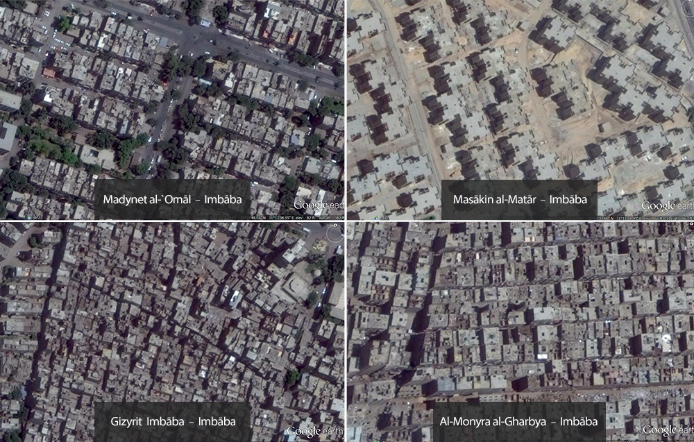
Diversity of urban fabrics: the same scale photographs illustrate the difference between the height and area occupied by residential buildings and the width of the streets and their planning within the various regions of Imbāba.
Imbāba’s situation also raises a number of questions and important considerations which criticize and review the top down planning mechanisms and management of development projects in general. No one could deny the importance of providing service centers to an area in dire need for it. Widening the streets may be a good step towards facilitating mobility within the city and it is likely that it will benefit busy, densely populated residential areas; however, there is a need to reexamine the decision-making mechanism and its application. An action such as eviction could disrupt the lives of residents of entire areas. It is a given within international bodies that there are criteria for evictions for the purposes of re-development. Primarily that such a process should be voluntary – in other words it should be in consultation with the residents and with their agreement. The damages suffered by individuals have to be calculated and they have to be equitably compensated in a way which is acceptable to them. All possible guarantees with respect to this compensation has to be made available to residents. They also have to be re-housed before demolition work starts so that they do not suffer any more hardships during the evacuation process or risk of becoming homeless under any circumstances. Frequently, officials and urban planners raise the issue of public interest and claim that resolving the problems of a densely populated area such as Imbāba cannot be carried out without some negative impacts on some individuals. What we are suggesting is that guaranteeing the rights of the few is not incompatible with public interest but is almost a condition towards achieving it if we are seeking sustainability and integrated development solutions. We have to transcend this duality in order to understand more wide-ranging models which can guarantee the rights of the few as well as that of the public. Public interest is the interest of the residents of Imbāba in the first degree and development has to center on their lives and their needs as it is not merely an improvement of streets and buildings. The case of Imbāba Airport Development is a glaring example of development in isolation, ignoring the impact of the project on the lives of residents in surrounding areas. Just as the planning for the workers’ cities of the 1950’s did not encompass the villages and the surrounding informal dwellings, the plans for the Airport Project did not include the impact on `Izbat al-Maṭār, Madinat al-Amal, al-Barāgīl, al- Munīra al-Gharbiyya and all the surrounding areas. This will undoubtedly create more informal settlements in these areas.
Finally, the residents of the various areas of Imbāba we talked to want their urgent need for clean, safe dwellings to be addressed. They believe that the most important issue in any development project in Imbāba is to provide them with services and basic amenities especially the management of solid waste which is a burden for all. Of equal importance is cleaning the streets, paving them and ensuring they are well-lit as well as providing the area with green spaces as an outlet for them, and certainly not depriving them of the corniche along the banks of the Nile by selling it to restaurants and luxury hotels. They do not want fancy schools, hospitals or sporting clubs which they would never be able to access. They only want their area’s services and recreational facilities to be accessible to them. They do want their neighborhoods to improve and they want whatever project to this end to be more respectful of their humanity.
Work cited
Asef Bayat and Eric Denis, “Who is afraid of ashwaiyyat? – Urban change and politics in Egypt”, Environment &Urbanization Vol. 12 No 2 October 2000
Mike Davis, Planet of Slums, 2006
Cairo 1001 Years of the City victorious, Janet L. Abu-Lughod, 1971
The Moulids of Egypt, J. W. Mcpherson. 1941
Workers on the Nile: Nationalism, communism, Islam, and the Egyptian working class, 1882-1954, Joel Beinin and Zachary Lockman. 1998
Industrial architecture in Egypt from Muhammad ‘Ali to Sadat: A field survey, Ralph Bodenstein, Workplaces: The Transformation of places of production (Industrialization and built environment in the Islamic world), edited by Mohammad al-Asad, 2010
Nancy Reynolds, A City Consumed: Urban Commerce, the Cairo Fire, and the Politics of Decolonization in Egypt, 2012
Mercedes Volait, Town planning schemes for Cairo conceived by Egyptian Planners in the liberal experiment period, Extrait de Hans Chr. Korsholm Nielsen and Jakob, Skovgaard-Petersen (ed.), Middle Eastern Cities 1900-1950. Publics Places and Publics Spheres in Transformation, Aarhus University Press, 2001, 44-71. Link
Architectes et architectures de l’Egypte moderne, 1830-1950 Mercedes Volait. 2005
David Sims, Understanding Cairo: The logic of a city out of control. 2012]
Andre Peronnet, Thomas Rodemeier, ETH Studio Basel Contemporary City Institute, The middle East Studio. 2010
Piffero, Elena. “What Happened to Participation: Urban Development and Authoritarian Upgrading in Cairo’s Informal Neighbourhoods”.2010 2009.
Dorman, W.Judson. “The Politics of Neglect: The Egyptian State in Cairo, 1974-98.” PHD, School of Oriental and African Studies, 2007.
Raymond, André. Cairo. Harvard University Press, 2000
Asef Bayat. “Life as Politics: How Ordinary People Change the Middle East”. 2009
Diane Singerman, The Siege of Imbāba, Egypt’s Internal ‘other,’ and the Criminalization of Politics. Cairo contested: Governance, urban space, and global modernity, 2009-2011
Diane Singerman , The Siege of Imbaba, Egypt’s Internal ‘other,’ and the Criminalization of Politics. Cairo contested: Governance, urban space, and global modernity , 2009-2011
Patrick Haenni, Cousins, Neighbors, and Citizens in Imbāba: The genesis and self-neutralization of a rebel political territory. Cairo contested: Governance, urban space, and global modernity, 2009-2011
Marwa A. Khalifa, Redefining slums in Egypt: Unplanned versus unsafe areas. Habitat International Journal 35 (2011) 40-49
1. The government estimate referred to here is based on the data published on the official website of the Cairo Governorate. While other government sources mention different data for proximate years, the report “Description of Egypt’s Governorates Through Information, 2010” issued by the Information and Decision Support Centre affiliated to the prime minister, mentions that the area of the North District is 8.45 km2 and a population of 687,350 inhabitants. The report “Spatial Analysis and Development Opportunities, 2012” issued by the General Organization for Physical Planning, affiliated to the Ministry of Housing, Utilities and Urban Communities mentions that the population of the Imbāba district (its borders coincide with that of the North Giza District) is about 543,000 inhabitants.
2. The report by the General Organization for Physical Planning previously referred to shows the borders of Imbāba on the map of the Ministry of Housing, Utilities and Urban Communities coincidong with the borders of the urban space of North Giza district on the map of the governorate.
3. According to the report “Description of Egypt’s Governorates Through Information, 2010” issued by the Information and Decision Support Centre affiliated to the prime minister, the general census issued by Central Agency for Public Mobilization and Statistics 2006, and other sources.
4. Al `Imāra magazine is the first magazine in Egypt and the Middle East to document and present architectural work in Arabic, founded by the architect and urban planner Sayyid Karīm and co-edited by architect Alī Labīb Gabr; the first issue was published in 1939 , the magazine was used to present new architectural styles that were globally popular and selections from the works of Egyptian architects of that era, it also had a significant impact on a whole generation of architects taught by Karīm and Gabr in their capacity as professors at Cairo University (Bodenstein, 2010).
5. The researchers studying labor movements document the sit-in of Chūrbagī factory workers in 1953, as an important mark in the history of the labor movement; where the workers gathered to demand their rights and chanted slogans against the factory management and government, the events escalated violently as the army stormed into the factory, and arrested between 350 and 500 workers in September 1953 (Beinin and Lockman, 1998).
6. The Law No. 206 year 1951 concerning the Public Housing was cancelled by Law No. 3 year 1982 concerning Urban Planning.
7. An interview with a group of Imbāba residents, the mentioned report is by a 60 year old resident, born in Imbāba (he is considered one of the community leaders in one of the old Imbāba areas)
8. These divisions have no references to administrative divisions or to residents’ local knowledge; it is just a method to facilitate describing the physical planning of Imbāba.
9. The Informal Settlements Development Fund was established in 2008 as an organization affiliated to the prime minister, then in 2014 it became the Ministry of State for Urban Renewal and Informal Settlements, headed by Dr. Laila Iskandar. Recently it was returned to the Ministry of Housing, Utilities and Urban Communities; the Ministry for Urban Renewal was abolished in the new cabinet on September 19th, 2015.
10. The study “Spatial Analysis and Development Opportunities” attached to the issuance of the General Organization for Physical Planning, which was carried out within the framework of the strategic plan of Greater Cairo project and the creation of a data base for it. According to the organization the study was carried out “according to modern urban work for the main urban block in Greater Cairo in 2009, in which many domestic and international consulting firms participated, it included the usage of land, heights and conditions of buildings, homogeneous regions and ownership. This study is considered as a modern diagnostic study of Greater Cairo.” – Urban development strategy for the Greater Cairo Region, the General organization for Physical planning, the Ministry of Housing, Utilities and Urban Communities, 2012
11. The announced percentage of unplanned areas as per the Informal Settlements Development Fund


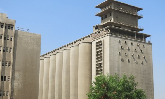
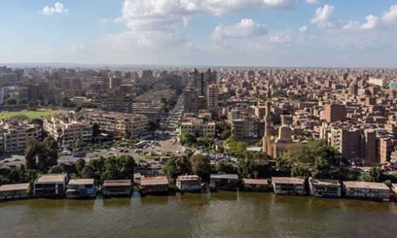

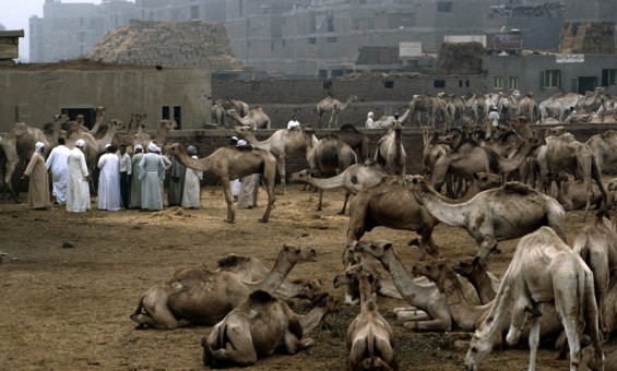
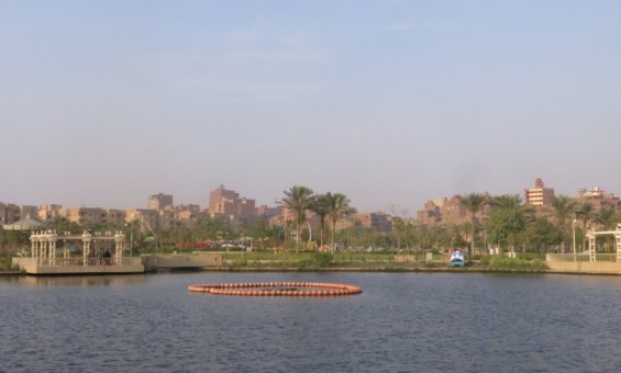
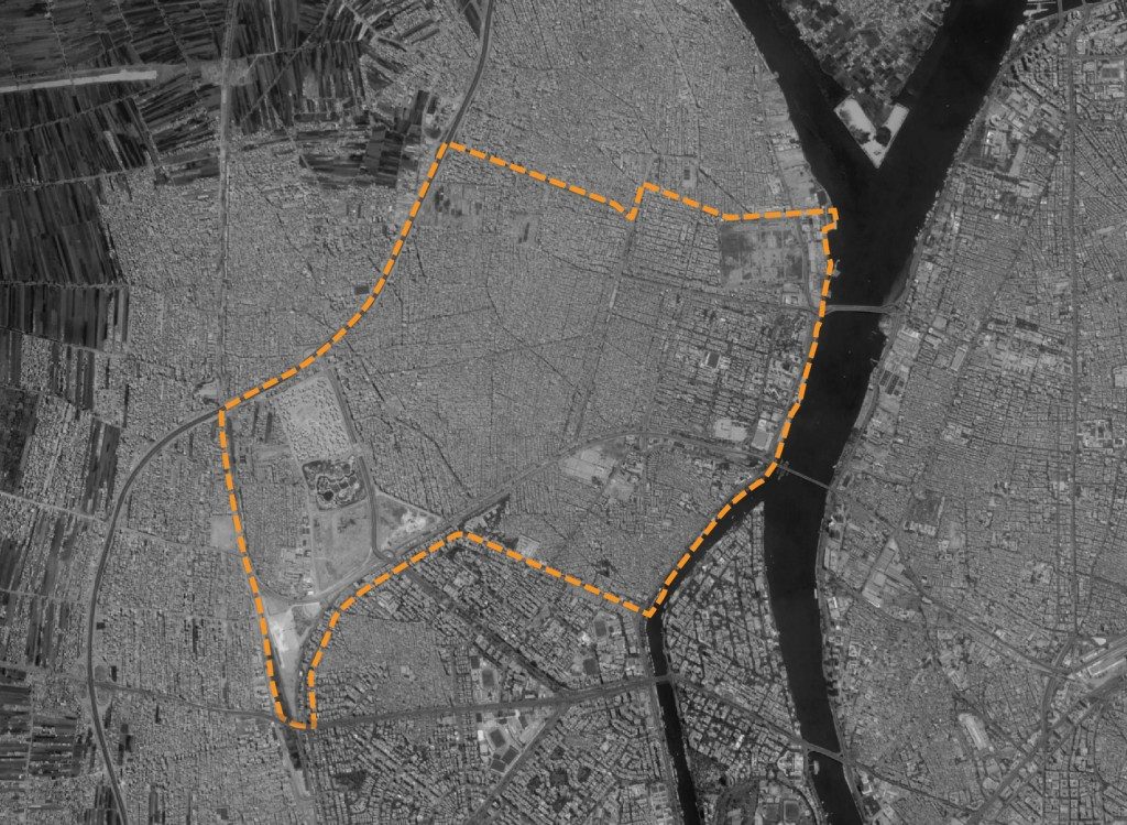
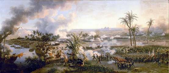
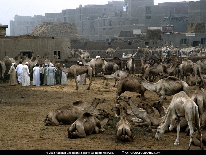
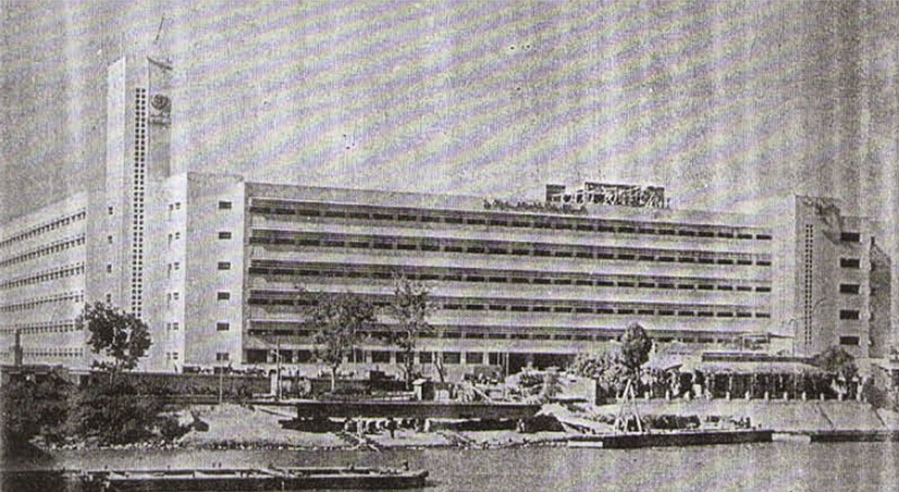
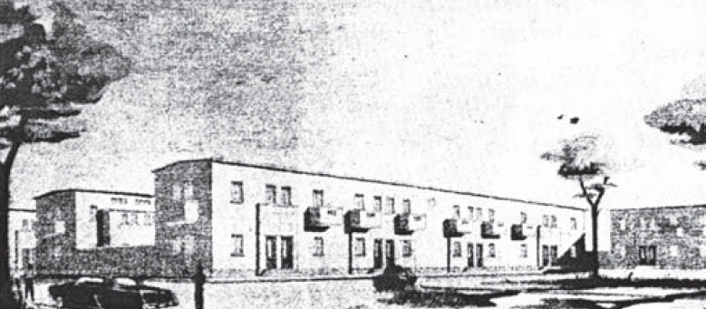
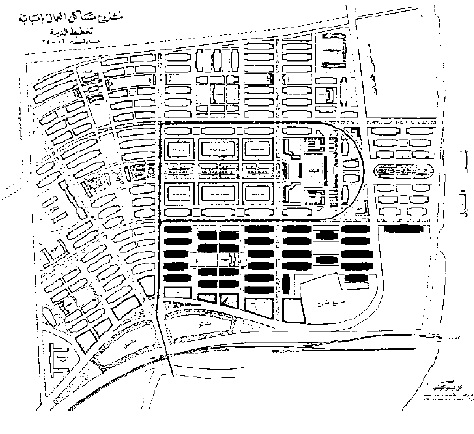
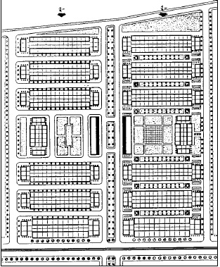
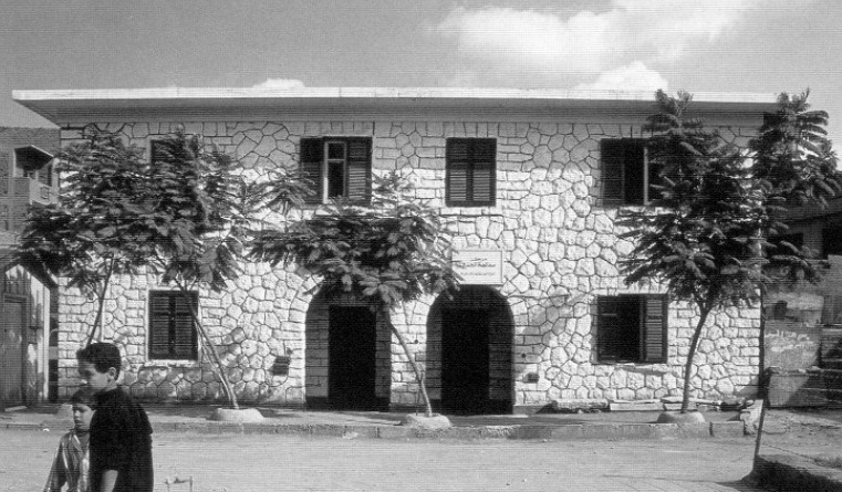
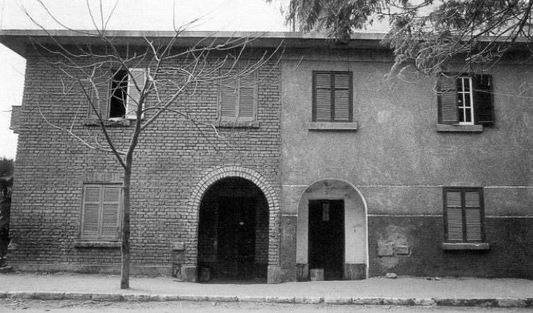
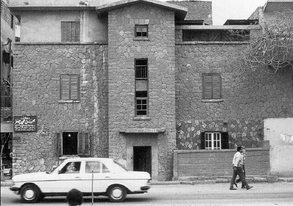
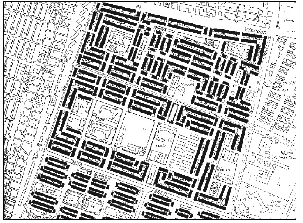
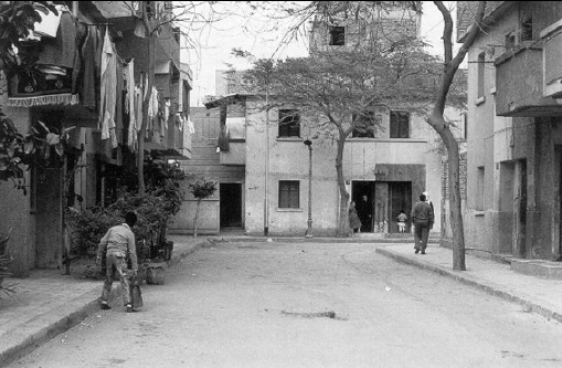
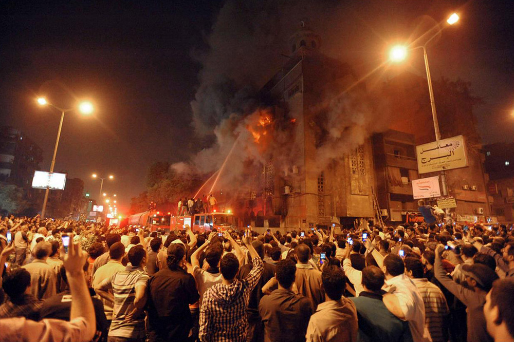
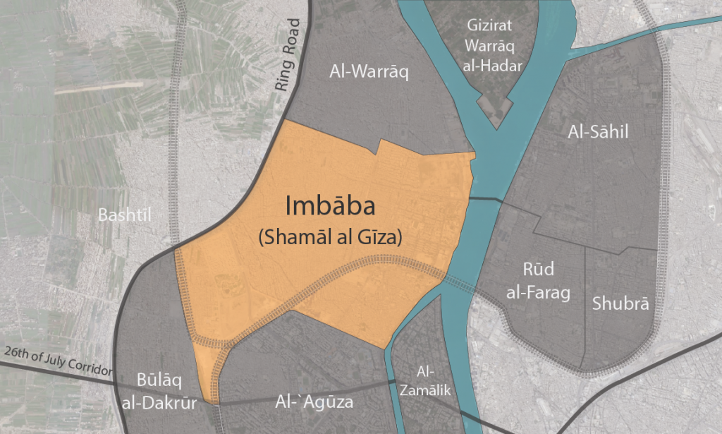
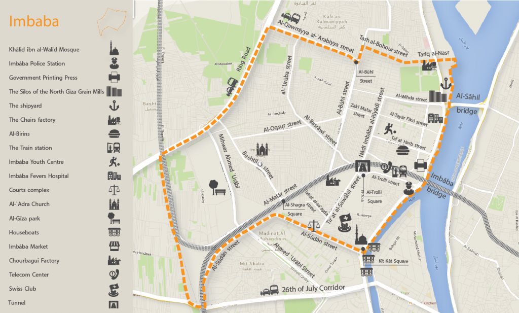
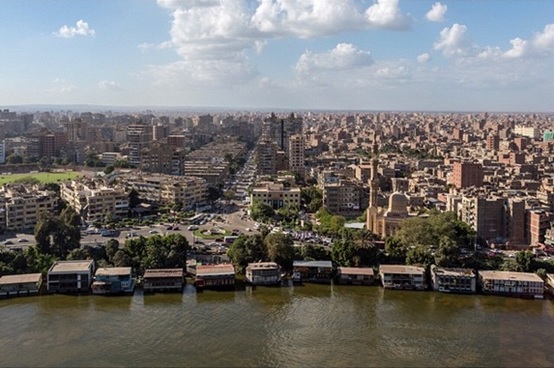
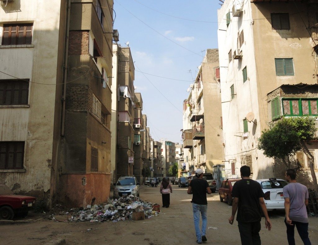
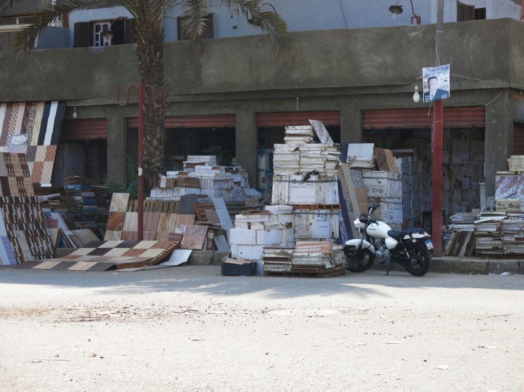
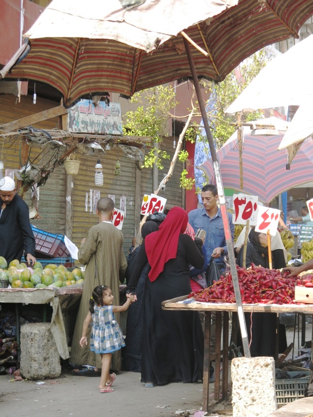
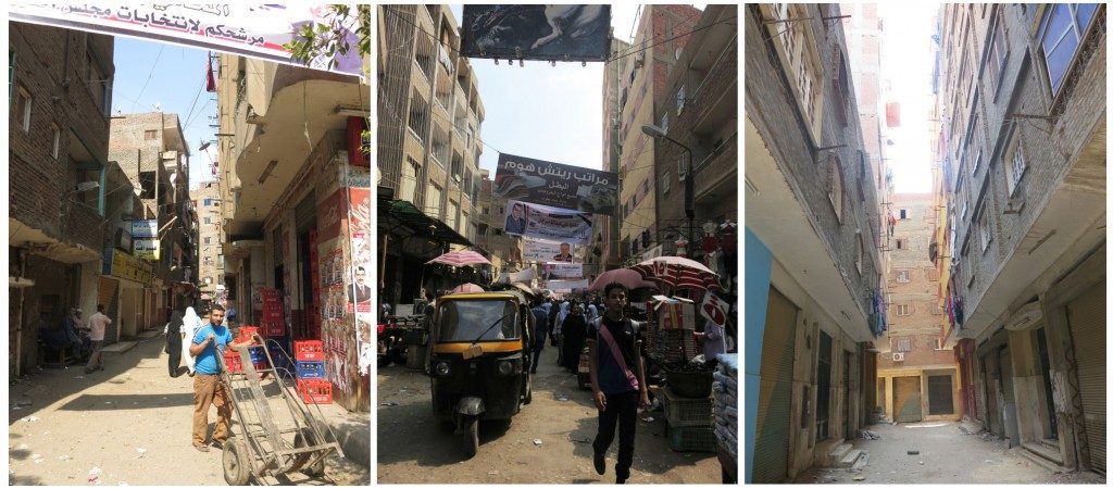
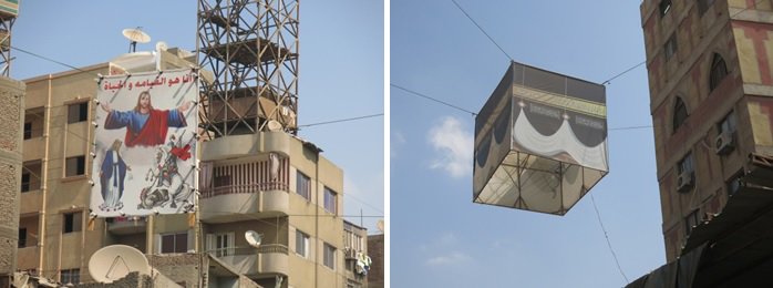
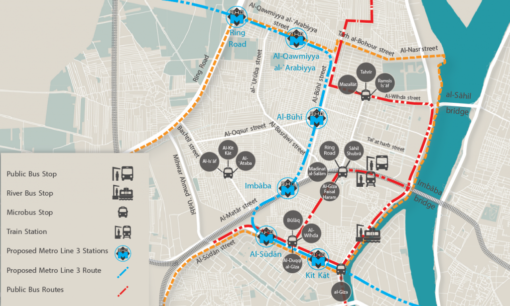
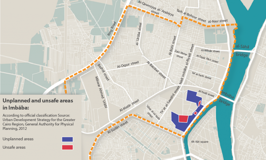

Comments